Poster Print > Maps and Charts > World
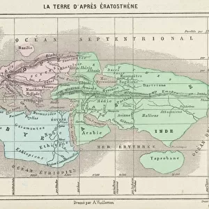
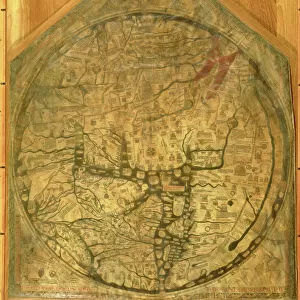
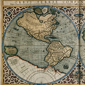
Poster Print : World map according to Eratosthenes


![]()
Poster Prints from Fine Art Storehouse
World map according to Eratosthenes
World map according to Eratosthenes - Scanned 1899 Engraving
Unleash your creativity and transform your space into a visual masterpiece!
benoitb
Media ID 18106837
20x30 inch Poster Print
Discover the fascinating history of cartography with our Media Storehouse range of poster prints featuring the "World Map according to Eratosthenes" by benoitb from Fine Art Storehouse. This captivating 1899 engraving offers a unique glimpse into ancient geographical knowledge. Eratosthenes, an ancient Greek philosopher, is credited with creating one of the first world maps based on scientific principles. His map, while not an accurate representation of the world, is an intriguing testament to the curiosity and ingenuity of ancient scholars. Bring a piece of historical cartography into your home or office with this beautifully scanned and preserved poster print. Order yours today and ignite your imagination!
Poster prints are budget friendly enlarged prints in standard poster paper sizes. Printed on 150 gsm Matte Paper for a natural feel and supplied rolled in a tube. Great for framing and should last many years. To clean wipe with a microfiber, non-abrasive cloth or napkin. Our Archival Quality Photo Prints and Fine Art Paper Prints are printed on higher quality paper and the choice of which largely depends on your budget.
Poster prints are budget friendly enlarged prints in standard poster paper sizes (A0, A1, A2, A3 etc). Whilst poster paper is sometimes thinner and less durable than our other paper types, they are still ok for framing and should last many years. Our Archival Quality Photo Prints and Fine Art Paper Prints are printed on higher quality paper and the choice of which largely depends on your budget.
Estimated Product Size is 76.8cm x 51.4cm (30.2" x 20.2")
These are individually made so all sizes are approximate
Artwork printed orientated as per the preview above, with landscape (horizontal) or portrait (vertical) orientation to match the source image.
FEATURES IN THESE COLLECTIONS
> Fine Art Storehouse
> Map
> Historical Maps
> Maps and Charts
> Related Images
> Maps and Charts
> World
EDITORS COMMENTS
This print showcases the incredible "World map according to Eratosthenes" a scanned 1899 engraving that takes us back in time to explore the ancient world. Created by Benoitb, this artwork beautifully captures the essence of Eratosthenes' vision and his profound contribution to cartography. Eratosthenes, a renowned Greek mathematician and geographer, meticulously charted the known world during his era. This remarkable map transports us to an era where Scythia, Ariana, Sogdiana, and Brettania were prominent regions on Earth's canvas. It offers a glimpse into how our ancestors perceived their surroundings and navigated through vast lands. The intricate details of this engraving are truly awe-inspiring. Every line etched with precision tells a story of exploration and discovery. The delicate strokes bring life to mountains, rivers, coastlines, and borders that once defined civilizations long gone but not forgotten. As we gaze upon this historical masterpiece from Fine Art Storehouse's collection, we can't help but marvel at how far humanity has come in mapping our planet since Eratosthenes' time. It serves as a reminder of our innate curiosity about the world around us—a curiosity that continues to drive scientific advancements today. Benoitb's photograph preserves this invaluable piece of history for generations to come. Through it, we are transported across continents and centuries—immersing ourselves in an ancient perspective while appreciating the artistry behind one man
MADE IN THE USA
Safe Shipping with 30 Day Money Back Guarantee
FREE PERSONALISATION*
We are proud to offer a range of customisation features including Personalised Captions, Color Filters and Picture Zoom Tools
SECURE PAYMENTS
We happily accept a wide range of payment options so you can pay for the things you need in the way that is most convenient for you
* Options may vary by product and licensing agreement. Zoomed Pictures can be adjusted in the Basket.