Canvas Print > Maps and Charts > World
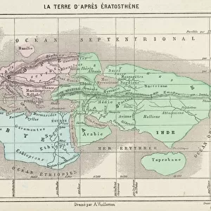
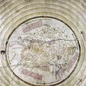
Canvas Print : World map according to Eratosthenes


![]()
Canvas Prints from Fine Art Storehouse
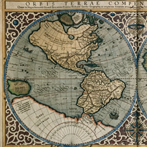
World map according to Eratosthenes
World map according to Eratosthenes - Scanned 1899 Engraving
Unleash your creativity and transform your space into a visual masterpiece!
benoitb
Media ID 18106837
30"x20" (76x51cm) Canvas Print
Discover the fascinating history of cartography with our Media Storehouse Canvas Print featuring the World Map according to Eratosthenes. This exquisite piece, sourced from the Fine Art Storehouse, showcases an 1899 engraving by benoitb. Eratosthenes of Cyrene, an ancient Greek mathematician and geographer, is renowned for being the first person to calculate the Earth's spherical shape and size. This captivating map is a testament to his groundbreaking achievements and offers a unique perspective on the ancient world. Elevate your home or office décor with this intriguing and educational canvas print, a perfect conversation starter and a reminder of the rich history of geography.
Delivered stretched and ready to hang our premium quality canvas prints are made from a polyester/cotton blend canvas and stretched over a 1.25" (32mm) kiln dried knot free wood stretcher bar. Packaged in a plastic bag and secured to a cardboard insert for safe transit.
Canvas Prints add colour, depth and texture to any space. Professionally Stretched Canvas over a hidden Wooden Box Frame and Ready to Hang
Estimated Product Size is 76.2cm x 50.8cm (30" x 20")
These are individually made so all sizes are approximate
Artwork printed orientated as per the preview above, with landscape (horizontal) orientation to match the source image.
FEATURES IN THESE COLLECTIONS
> Maps and Charts
> Related Images
> Maps and Charts
> World
> Fine Art Storehouse
> Map
> Historical Maps
EDITORS COMMENTS
This print showcases the incredible "World map according to Eratosthenes" a scanned 1899 engraving that takes us back in time to explore the ancient world. Created by Benoitb, this artwork beautifully captures the essence of Eratosthenes' vision and his profound contribution to cartography. Eratosthenes, a renowned Greek mathematician and geographer, meticulously charted the known world during his era. This remarkable map transports us to an era where Scythia, Ariana, Sogdiana, and Brettania were prominent regions on Earth's canvas. It offers a glimpse into how our ancestors perceived their surroundings and navigated through vast lands. The intricate details of this engraving are truly awe-inspiring. Every line etched with precision tells a story of exploration and discovery. The delicate strokes bring life to mountains, rivers, coastlines, and borders that once defined civilizations long gone but not forgotten. As we gaze upon this historical masterpiece from Fine Art Storehouse's collection, we can't help but marvel at how far humanity has come in mapping our planet since Eratosthenes' time. It serves as a reminder of our innate curiosity about the world around us—a curiosity that continues to drive scientific advancements today. Benoitb's photograph preserves this invaluable piece of history for generations to come. Through it, we are transported across continents and centuries—immersing ourselves in an ancient perspective while appreciating the artistry behind one man
MADE IN THE USA
Safe Shipping with 30 Day Money Back Guarantee
FREE PERSONALISATION*
We are proud to offer a range of customisation features including Personalised Captions, Color Filters and Picture Zoom Tools
SECURE PAYMENTS
We happily accept a wide range of payment options so you can pay for the things you need in the way that is most convenient for you
* Options may vary by product and licensing agreement. Zoomed Pictures can be adjusted in the Cart.