Photographic Print > Europe > United Kingdom > England > London > Boroughs > Hackney
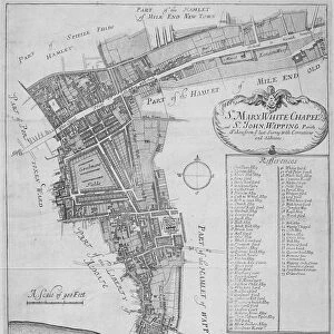
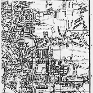
Photographic Print : Map of Victoria Park

![]()
Photo Prints From Mary Evans Picture Library
Map of Victoria Park
The proprosed plan of Victoria Park, Bethnal Green. The entire tract of land lying between the Hackney and Whitechapel roads contains about 290 acres
Mary Evans Picture Library makes available wonderful images created for people to enjoy over the centuries
Media ID 4465391
© Mary Evans Picture Library 2015 - https://copyrighthub.org/s0/hub1/creation/maryevans/MaryEvansPictureID/10416262
12"x8" Photo Print
Introducing the exquisite "Map of Victoria Park" photograph from the Media Storehouse range of Photographic Prints, sourced from Mary Evans Prints Online. This captivating image provides a rare glimpse into the past, showcasing a proposed plan of Victoria Park in Bethnal Green, London. Covering approximately 290 acres between Hackney and Whitechapel roads, this historic map invites you to explore the rich history and development of this iconic urban green space. Bring the intriguing story of Victoria Park into your home or office with this stunning, rights managed print. Perfect for architects, historians, or anyone with an appreciation for the evolution of urban landscapes, this photograph is a must-have addition to your collection. Order now and let the captivating details of this map transport you back in time.
Photo prints are produced on Kodak professional photo paper resulting in timeless and breath-taking prints which are also ideal for framing. The colors produced are rich and vivid, with accurate blacks and pristine whites, resulting in prints that are truly timeless and magnificent. Whether you're looking to display your prints in your home, office, or gallery, our range of photographic prints are sure to impress. Dimensions refers to the size of the paper in inches.
Our Photo Prints are in a large range of sizes and are printed on Archival Quality Paper for excellent colour reproduction and longevity. They are ideal for framing (our Framed Prints use these) at a reasonable cost. Alternatives include cheaper Poster Prints and higher quality Fine Art Paper, the choice of which is largely dependant on your budget.
Estimated Product Size is 30.5cm x 20.3cm (12" x 8")
These are individually made so all sizes are approximate
Artwork printed orientated as per the preview above, with landscape (horizontal) orientation to match the source image.
FEATURES IN THESE COLLECTIONS
> Europe
> France
> Canton
> Landes
> Europe
> United Kingdom
> England
> London
> Boroughs
> Hackney
> Europe
> United Kingdom
> England
> London
> Sights
> Victoria Park
> Maps and Charts
> Early Maps
> Maps and Charts
> Related Images
MADE IN THE USA
Safe Shipping with 30 Day Money Back Guarantee
FREE PERSONALISATION*
We are proud to offer a range of customisation features including Personalised Captions, Color Filters and Picture Zoom Tools
SECURE PAYMENTS
We happily accept a wide range of payment options so you can pay for the things you need in the way that is most convenient for you
* Options may vary by product and licensing agreement. Zoomed Pictures can be adjusted in the Basket.