Canvas Print > Europe > United Kingdom > England > London > Boroughs > Hackney
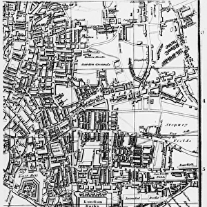
Canvas Print : Map of Victoria Park


![]()
Canvas Prints From Mary Evans Picture Library
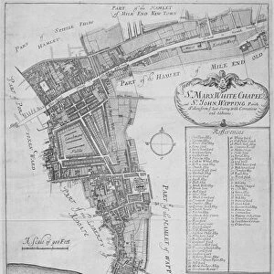
Map of Victoria Park
The proprosed plan of Victoria Park, Bethnal Green. The entire tract of land lying between the Hackney and Whitechapel roads contains about 290 acres
Mary Evans Picture Library makes available wonderful images created for people to enjoy over the centuries
Media ID 4465391
© Mary Evans Picture Library 2015 - https://copyrighthub.org/s0/hub1/creation/maryevans/MaryEvansPictureID/10416262
30"x20" (76x51cm) Canvas Print
Introducing the exquisite "Map of Victoria Park" Canvas Print from Media Storehouse, an essential addition to your home or office décor. This stunning piece, sourced from Mary Evans Prints Online, showcases a historical map of Victoria Park in Bethnal Green, London. The proposed plan of this expansive 290-acre green space, located between Hackney and Whitechapel roads, is beautifully rendered in intricate detail. Our high-quality canvas prints bring out the rich colors and textures of the original image, making it a captivating conversation starter. Elevate your space with a touch of history and the timeless beauty of Victoria Park.
Delivered stretched and ready to hang our premium quality canvas prints are made from a polyester/cotton blend canvas and stretched over a 1.25" (32mm) kiln dried knot free wood stretcher bar. Packaged in a plastic bag and secured to a cardboard insert for safe transit.
Canvas Prints add colour, depth and texture to any space. Professionally Stretched Canvas over a hidden Wooden Box Frame and Ready to Hang
Estimated Product Size is 76.2cm x 50.8cm (30" x 20")
These are individually made so all sizes are approximate
Artwork printed orientated as per the preview above, with landscape (horizontal) orientation to match the source image.
FEATURES IN THESE COLLECTIONS
> Europe
> France
> Canton
> Landes
> Europe
> United Kingdom
> England
> London
> Boroughs
> Hackney
> Europe
> United Kingdom
> England
> London
> Sights
> Victoria Park
> Maps and Charts
> Early Maps
> Maps and Charts
> Related Images
MADE IN THE USA
Safe Shipping with 30 Day Money Back Guarantee
FREE PERSONALISATION*
We are proud to offer a range of customisation features including Personalised Captions, Color Filters and Picture Zoom Tools
SECURE PAYMENTS
We happily accept a wide range of payment options so you can pay for the things you need in the way that is most convenient for you
* Options may vary by product and licensing agreement. Zoomed Pictures can be adjusted in the Basket.