Metal Print > North America > United States of America > New York > New York > Maps
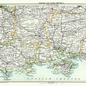
Metal Print : Map of Dorset 1883


![]()
Metal Prints from Fine Art Storehouse
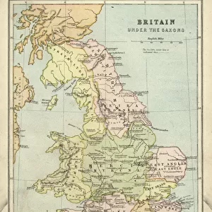
Map of Dorset 1883
Encyclopedia Britannica 9th Edition New York Samuel L. Hall 1883 Vol VII
Unleash your creativity and transform your space into a visual masterpiece!
THEPALMER
Media ID 14549465
© This content is subject to copyright
16"x20" (51x41cm) Metal Print
Discover the rich history of Dorset with our stunning Metal Print of the Map of Dorset 1883 by THEPALMER from our Media Storehouse collection. This exquisite piece, sourced from the Encyclopedia Britannica 9th Edition New York Samuel L. Hall 1883 Vol VII, brings a touch of nostalgia and historical charm to any space. The intricate details of the map are beautifully preserved in the vibrant colors and high-quality finish of the metal print. Elevate your home or office decor with this unique and captivating piece of historical cartography.
Made with durable metal and luxurious printing techniques, our metal photo prints go beyond traditional canvases, adding a cool, modern touch to your space. Wall mount on back. Eco-friendly 100% post-consumer recycled ChromaLuxe aluminum surface. The thickness of the print is 0.045". Featuring a Scratch-resistant surface and Rounded corners. Backing hangers are attached to the back of the print and float the print 1/2-inch off the wall when hung, the choice of hanger may vary depending on size and International orders will come with Float Mount hangers only. Finished with a brilliant white high gloss surface for unsurpassed detail and vibrance. Printed using Dye-Sublimation and for best care we recommend a non-ammonia glass cleaner, water, or isopropyl (rubbing) alcohol to prevent harming the print surface. We recommend using a clean, lint-free cloth to wipe off the print. The ultra-hard surface is scratch-resistant, waterproof and weatherproof. Avoid direct sunlight exposure.
Made with durable metal and luxurious printing techniques, metal prints bring images to life and add a modern touch to any space
Estimated Image Size (if not cropped) is 50.8cm x 40.6cm (20" x 16")
Estimated Product Size is 51.4cm x 41.2cm (20.2" x 16.2")
These are individually made so all sizes are approximate
Artwork printed orientated as per the preview above, with landscape (horizontal) orientation to match the source image.
FEATURES IN THESE COLLECTIONS
> Fine Art Storehouse
> Map
> Historical Maps
> Europe
> United Kingdom
> England
> Dorset
> Related Images
> Europe
> United Kingdom
> Maps
> Maps and Charts
> Related Images
> North America
> United States of America
> New York
> New York
> Maps
> North America
> United States of America
> New York
> Related Images
EDITORS COMMENTS
This print showcases a remarkable piece of history, the "Map of Dorset 1883" sourced from the Encyclopedia Britannica 9th Edition. A true treasure for enthusiasts and collectors alike, this vintage map takes us back to a bygone era when cartography was an art form in itself. The intricate details and exquisite craftsmanship captured in this print transport us to Great Britain's picturesque county of Dorset during the late 19th century. Every line, contour, and symbol on this map tells a story about the land it represents - its towns, villages, rivers, hills, and coastlines come alive before our eyes. As we gaze upon this stunning work by THEPALMER from Fine Art Storehouse, we are reminded of how maps have always been essential tools for exploration and understanding. They offer glimpses into the past while guiding us towards new horizons. Whether you are a history buff or simply appreciate fine art prints that evoke nostalgia and curiosity simultaneously, this Map of Dorset will undoubtedly captivate your imagination. It serves as both an educational resource for those seeking knowledge about British geography at that time and as a beautiful decorative piece that adds character to any space. Let yourself be transported through time with this extraordinary print – immerse yourself in the rich heritage of Dorset County as seen through the lens of Samuel L. Hall's expertise in cartography.
MADE IN THE USA
Safe Shipping with 30 Day Money Back Guarantee
FREE PERSONALISATION*
We are proud to offer a range of customisation features including Personalised Captions, Color Filters and Picture Zoom Tools
SECURE PAYMENTS
We happily accept a wide range of payment options so you can pay for the things you need in the way that is most convenient for you
* Options may vary by product and licensing agreement. Zoomed Pictures can be adjusted in the Cart.