Canvas Print > North America > United States of America > New York > New York > Maps
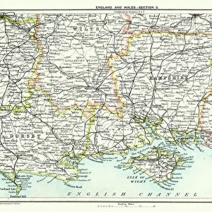
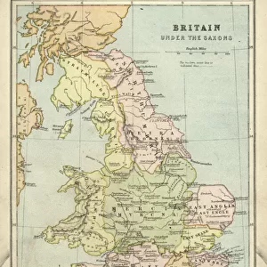
Canvas Print : Map of Dorset 1883


![]()
Canvas Prints from Fine Art Storehouse
Map of Dorset 1883
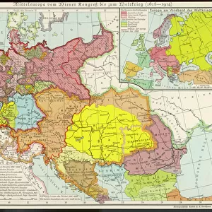
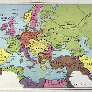
Encyclopedia Britannica 9th Edition New York Samuel L. Hall 1883 Vol VII
Unleash your creativity and transform your space into a visual masterpiece!
THEPALMER
Media ID 14549465
© This content is subject to copyright
20"x16" (51x41cm) Canvas Print
Introducing the exquisite "Map of Dorset 1883" by THEPALMER from our Media Storehouse Canvas Print collection. This stunning piece is a reproduction of a map taken from the Encyclopedia Britannica 9th Edition, published in New York by Samuel L. Hall in 1883. The intricate details of this vintage map of Dorset, England, are brought to life with our premium canvas printing process. Each print is carefully crafted to preserve the historical accuracy and rich, authentic details of the original. Adorn your walls with a piece of history and add a touch of timeless charm to any room. Order your "Map of Dorset 1883" Canvas Print from Media Storehouse today.
Delivered stretched and ready to hang our premium quality canvas prints are made from a polyester/cotton blend canvas and stretched over a 1.25" (32mm) kiln dried knot free wood stretcher bar. Packaged in a plastic bag and secured to a cardboard insert for safe transit.
Canvas Prints add colour, depth and texture to any space. Professionally Stretched Canvas over a hidden Wooden Box Frame and Ready to Hang
Estimated Product Size is 50.8cm x 40.6cm (20" x 16")
These are individually made so all sizes are approximate
Artwork printed orientated as per the preview above, with landscape (horizontal) orientation to match the source image.
FEATURES IN THESE COLLECTIONS
> Europe
> United Kingdom
> England
> Dorset
> Related Images
> Europe
> United Kingdom
> Maps
> Maps and Charts
> Related Images
> North America
> United States of America
> New York
> New York
> Maps
> North America
> United States of America
> New York
> Related Images
> Fine Art Storehouse
> Map
> Historical Maps
EDITORS COMMENTS
This print showcases a remarkable piece of history, the "Map of Dorset 1883" sourced from the Encyclopedia Britannica 9th Edition. A true treasure for enthusiasts and collectors alike, this vintage map takes us back to a bygone era when cartography was an art form in itself. The intricate details and exquisite craftsmanship captured in this print transport us to Great Britain's picturesque county of Dorset during the late 19th century. Every line, contour, and symbol on this map tells a story about the land it represents - its towns, villages, rivers, hills, and coastlines come alive before our eyes. As we gaze upon this stunning work by THEPALMER from Fine Art Storehouse, we are reminded of how maps have always been essential tools for exploration and understanding. They offer glimpses into the past while guiding us towards new horizons. Whether you are a history buff or simply appreciate fine art prints that evoke nostalgia and curiosity simultaneously, this Map of Dorset will undoubtedly captivate your imagination. It serves as both an educational resource for those seeking knowledge about British geography at that time and as a beautiful decorative piece that adds character to any space. Let yourself be transported through time with this extraordinary print – immerse yourself in the rich heritage of Dorset County as seen through the lens of Samuel L. Hall's expertise in cartography.
MADE IN THE USA
Safe Shipping with 30 Day Money Back Guarantee
FREE PERSONALISATION*
We are proud to offer a range of customisation features including Personalised Captions, Color Filters and Picture Zoom Tools
SECURE PAYMENTS
We happily accept a wide range of payment options so you can pay for the things you need in the way that is most convenient for you
* Options may vary by product and licensing agreement. Zoomed Pictures can be adjusted in the Cart.