Photographic Print > Europe > United Kingdom > England > London > Politics > John Major
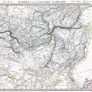
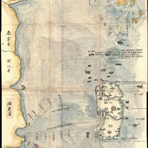
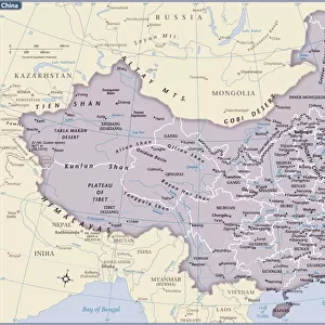
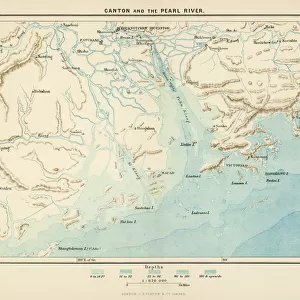
Photographic Print : CHINA: FUJIAN MAP, 1662. Engraved map of the province of Fujian, China, also showing the Strait of Taiwan and part of Taiwan (Formosa) from Jan Blaeus Atlas Major published in Amsterdam in 1662
 from Jan Blaeus Atlas Major published in Amsterdam in 1662")

![]()
Photo Prints from Granger
CHINA: FUJIAN MAP, 1662. Engraved map of the province of Fujian, China, also showing the Strait of Taiwan and part of Taiwan (Formosa) from Jan Blaeus Atlas Major published in Amsterdam in 1662
Granger holds millions of images spanning more than 25,000 years of world history, from before the Stone Age to the dawn of the Space Age
Media ID 7515197
1662 Atlas Blaeu Chinese Ching Dynasty Dutch Fujian Province Atlas Maior Formosa Taiwan
10"x8" Photo Print
Step back in time with our exquisite selection of antique maps from the Media Storehouse range. This captivating print showcases an engraved map of Fujian Province, China, from the renowned Jan Blaeus Atlas Major published in Amsterdam in 1662. Delve into the rich history of the region with intricate detail as you explore the province, the Strait of Taiwan, and part of Taiwan (Formosa) as they appeared over 350 years ago. Bring the historical charm of this rare map into your home or office and transport yourself on a journey through time. Order your antique Fujian map print today from Media Storehouse, brought to you through Granger Art on Demand.
Photo prints are produced on Kodak professional photo paper resulting in timeless and breath-taking prints which are also ideal for framing. The colors produced are rich and vivid, with accurate blacks and pristine whites, resulting in prints that are truly timeless and magnificent. Whether you're looking to display your prints in your home, office, or gallery, our range of photographic prints are sure to impress. Dimensions refers to the size of the paper in inches.
Our Photo Prints are in a large range of sizes and are printed on Archival Quality Paper for excellent colour reproduction and longevity. They are ideal for framing (our Framed Prints use these) at a reasonable cost. Alternatives include cheaper Poster Prints and higher quality Fine Art Paper, the choice of which is largely dependant on your budget.
Estimated Product Size is 25.4cm x 20.3cm (10" x 8")
These are individually made so all sizes are approximate
Artwork printed orientated as per the preview above, with landscape (horizontal) orientation to match the source image.
FEATURES IN THESE COLLECTIONS
> Granger Art on Demand
> Maps
> Animals
> Mammals
> Didelphidae
> Formosa
> Arts
> Artists
> B
> Jan Blaeu
> Arts
> Landscape paintings
> Waterfall and river artworks
> River artworks
> Asia
> Taiwan
> Related Images
> Europe
> United Kingdom
> England
> London
> Politics
> John Major
> Historic
> Ancient civilizations
> Chinese Dynasties
> Historic
> Chinese dynasties paintings
EDITORS COMMENTS
This print showcases a remarkable piece of cartographic history - the "CHINA: FUJIAN MAP, 1662". Engraved by the skilled hands of John Blaeu and published in Amsterdam during the same year, this map offers an exquisite depiction of Fujian province in China. With intricate details and precision, it not only encompasses the entire province but also reveals a glimpse of Taiwan (then known as Formosa) and the Strait of Taiwan. The fusion of Dutch and Chinese influences is evident in this masterpiece, reflecting cultural exchange during that era. The engraving itself is a testament to Blaeu's expertise as he skillfully captures every contour, river, and landmark with utmost accuracy. It serves as a valuable historical artifact from the Ching Dynasty period. Jan Blaeu's Atlas Major was renowned for its comprehensive collection of maps from around the world. This particular map holds significance due to its portrayal of Fujian Province - an area rich in natural beauty and cultural heritage. As we gaze upon this stunning print, we are transported back to 1662 when exploration was at its peak. It reminds us how maps were once treasured possessions that guided adventurers through uncharted territories. Thanks to Granger Art on Demand's impeccable preservation efforts, we can now admire this extraordinary engraving that seamlessly merges artistry with geographic knowledge.
MADE IN THE USA
Safe Shipping with 30 Day Money Back Guarantee
FREE PERSONALISATION*
We are proud to offer a range of customisation features including Personalised Captions, Color Filters and Picture Zoom Tools
SECURE PAYMENTS
We happily accept a wide range of payment options so you can pay for the things you need in the way that is most convenient for you
* Options may vary by product and licensing agreement. Zoomed Pictures can be adjusted in the Cart.