Photographic Print > North America > United States of America > New York > New York > Maps
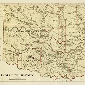
Photographic Print : Map of Indian territories 1894

![]()
Photo Prints from Fine Art Storehouse
Map of Indian territories 1894
Johnsons Universal Cyclopedia - Volume IV New York - A. J. Johnson Company 1894
Unleash your creativity and transform your space into a visual masterpiece!
THEPALMER
Media ID 18356747
10"x8" Photo Print
Step back in time with our exquisite 'Map of Indian Territories 1894' photographic print from THEPALMER's collection at Media Storehouse. This captivating piece is taken from the pages of Johnsons Universal Cyclopedia - Volume IV, published by A.J. Johnson Company in New York, 1894. Each print is meticulously reproduced from the original source, providing a stunningly detailed and accurate representation of historical cartography. Bring the rich history of the past into your home or office space with this intriguing and educational addition to your decor.
Photo prints are produced on Kodak professional photo paper resulting in timeless and breath-taking prints which are also ideal for framing. The colors produced are rich and vivid, with accurate blacks and pristine whites, resulting in prints that are truly timeless and magnificent. Whether you're looking to display your prints in your home, office, or gallery, our range of photographic prints are sure to impress. Dimensions refers to the size of the paper in inches.
Our Photo Prints are in a large range of sizes and are printed on Archival Quality Paper for excellent colour reproduction and longevity. They are ideal for framing (our Framed Prints use these) at a reasonable cost. Alternatives include cheaper Poster Prints and higher quality Fine Art Paper, the choice of which is largely dependant on your budget.
Estimated Product Size is 25.4cm x 20.3cm (10" x 8")
These are individually made so all sizes are approximate
Artwork printed orientated as per the preview above, with landscape (horizontal) or portrait (vertical) orientation to match the source image.
FEATURES IN THESE COLLECTIONS
> Fine Art Storehouse
> Map
> Historical Maps
> Maps and Charts
> Related Images
> North America
> United States of America
> New York
> New York
> Maps
> North America
> United States of America
> New York
> Related Images
EDITORS COMMENTS
This print showcases a historical gem, the "Map of Indian Territories 1894" sourced from Johnson's Universal Cyclopedia. A true testament to the rich tapestry of American history, this vintage map transports us back to an era when Native American tribes thrived across the vast expanse of North America. With its intricate details and vibrant colors, this print offers a fascinating glimpse into the territorial boundaries and tribal lands that defined Indian territories in 1894. The meticulous craftsmanship evident in every line and contour allows us to appreciate the cartographic expertise of A. J. Johnson Company, New York. As we explore this map, our imagination takes flight as we envision countless stories unfolding within these borders - tales of indigenous cultures flourishing amidst breathtaking landscapes. This visual representation serves as a reminder of their resilience and deep connection with nature. The photographer behind this remarkable image, known as THEPALMER from Fine Art Storehouse, has expertly captured not only the essence but also the historical significance embedded within this piece. Through his lens, he invites us to delve into an era long gone yet forever imprinted on our collective memory. Whether you are an avid history enthusiast or simply captivated by artful representations of our past, this print is sure to ignite your curiosity and transport you on a journey through time.
MADE IN THE USA
Safe Shipping with 30 Day Money Back Guarantee
FREE PERSONALISATION*
We are proud to offer a range of customisation features including Personalised Captions, Color Filters and Picture Zoom Tools
SECURE PAYMENTS
We happily accept a wide range of payment options so you can pay for the things you need in the way that is most convenient for you
* Options may vary by product and licensing agreement. Zoomed Pictures can be adjusted in the Cart.