Metal Print > Africa > Egypt > Maps
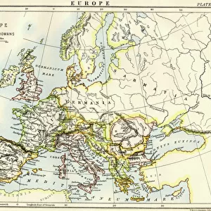
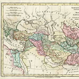
Metal Print : Map of the Roman Empire


![]()
Metal Prints from North Wind
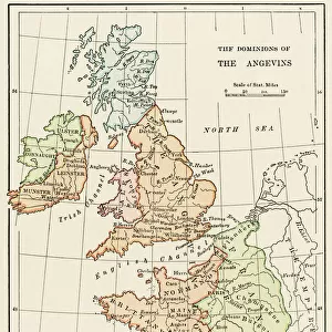
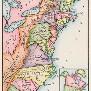
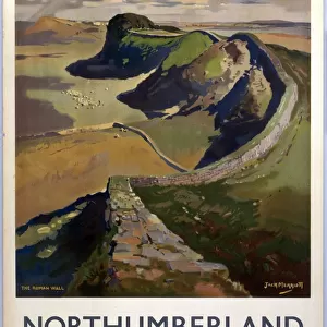
Map of the Roman Empire
Map showing the extent of the Roman Empire.
Hand-colored woodcut of a 19th-century illustration
North Wind Picture Archives brings history to life with stock images and hand-colored illustrations
Media ID 5878162
© North Wind Picture Archives
Africa Ancient Ancient Civilization Ancient History Ancient Roman Ancient Rome Antiquity Arabia Asia Minor British Isles Civilization Classical Classical Civilization Egypt Empire Europe European Gaul Italy Mediterranean Mediterranean Sea Mid East Middle East North Africa Roman Roman Empire Rome Territory Armenia Britannia Germania Hispania Sarmatia
16"x24" (61x41cm) Metal Print
Step back in time with our exquisite Metal Prints from Media Storehouse, featuring a captivating Map of the Roman Empire from North Wind Picture Archives. This intricately detailed, hand-colored woodcut illustration transports you back to the ancient world's grandeur. Each Metal Print is meticulously crafted, giving the map a vibrant, three-dimensional effect that brings history to life. Perfect for history enthusiasts, educators, or anyone who appreciates the beauty of historical art, this unique and stunning decor piece is sure to be a conversation starter in your home or office.
Made with durable metal and luxurious printing techniques, our metal photo prints go beyond traditional canvases, adding a cool, modern touch to your space. Wall mount on back. Eco-friendly 100% post-consumer recycled ChromaLuxe aluminum surface. The thickness of the print is 0.045". Featuring a Scratch-resistant surface and Rounded corners. Backing hangers are attached to the back of the print and float the print 1/2-inch off the wall when hung, the choice of hanger may vary depending on size and International orders will come with Float Mount hangers only. Finished with a brilliant white high gloss surface for unsurpassed detail and vibrance. Printed using Dye-Sublimation and for best care we recommend a non-ammonia glass cleaner, water, or isopropyl (rubbing) alcohol to prevent harming the print surface. We recommend using a clean, lint-free cloth to wipe off the print. The ultra-hard surface is scratch-resistant, waterproof and weatherproof. Avoid direct sunlight exposure.
Made with durable metal and luxurious printing techniques, metal prints bring images to life and add a modern touch to any space
Estimated Product Size is 61.5cm x 41.2cm (24.2" x 16.2")
These are individually made so all sizes are approximate
Artwork printed orientated as per the preview above, with landscape (horizontal) orientation to match the source image.
FEATURES IN THESE COLLECTIONS
> Africa
> Related Images
> Arts
> Artists
> R
> Roman Roman
> Asia
> Armenia
> Related Images
> Asia
> Related Images
> Europe
> Armenia
> Related Images
> Europe
> Italy
> Lazio
> Rome
> North Wind Picture Archives
> Ancient history
> North Wind Picture Archives
> Maps
EDITORS COMMENTS
This print showcases a meticulously hand-colored woodcut of a 19th-century illustration, depicting the grandeur and vastness of the Roman Empire. The map vividly portrays the extent of this ancient civilization, spanning across Europe, Asia Minor, North Africa, and parts of the Middle East. From Italy to Egypt, from Gaul to Armenia, from Britannia to Arabia - every corner of this mighty empire is meticulously detailed. The artwork beautifully captures the essence of classical antiquity and takes us on a journey through time. It serves as a visual testament to Rome's dominance in history and its profound impact on Western civilization. As we gaze upon this vintage masterpiece, we are reminded of the power and influence that once radiated from Rome. The Map of the Roman Empire not only provides geographical information but also offers glimpses into different cultures and territories that fell under Roman rule. It invites us to explore ancient cities like Pompeii or marvel at architectural wonders such as the Colosseum. With its rich colors and intricate details, this print transports us back in time to an era when emperors ruled with iron fists and legions marched across continents. It serves as a reminder that even though centuries have passed since its decline, the legacy of Rome continues to shape our world today
MADE IN THE USA
Safe Shipping with 30 Day Money Back Guarantee
FREE PERSONALISATION*
We are proud to offer a range of customisation features including Personalised Captions, Color Filters and Picture Zoom Tools
SECURE PAYMENTS
We happily accept a wide range of payment options so you can pay for the things you need in the way that is most convenient for you
* Options may vary by product and licensing agreement. Zoomed Pictures can be adjusted in the Cart.