Jigsaw Puzzle > Europe > United Kingdom > England > Derbyshire > Baslow
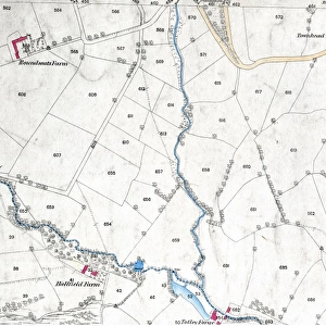
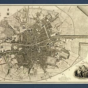
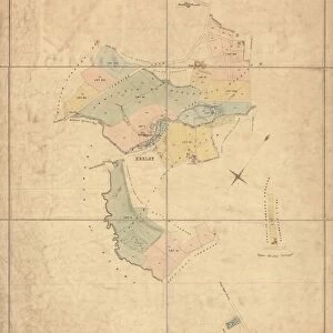
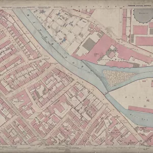
Jigsaw Puzzle : Ordnance Survey map: Totley, 1876


![]()
Jigsaw Puzzles from Sheffield City Archives
Ordnance Survey map: Totley, 1876
Scale: 25 inches to 1 mile.Original at Sheffield Local Studies Library: Derbyshire sheet XI.15.Includes: Old Hay Brook, Grove House, Crown Inn, Hillfoot, Totley Bents, Cricket Inn, recreation ground, Needhams Dike, Sunnybrook, Fleur de Lis Public House, Cross Scythes Public House, Totley Hall Farm, Infants School, Boys and girls School, Wesyleyan Methodist Chapel, The Folds
Sheffield City Archives and Local Studies Library has an unrivalled collection of images of Sheffield, England
Media ID 14050517
© Sheffield City Council
Brook Chapel Churches Cricket Farm Farming Farms Green Ground Hall Hill Hotel Hotels House Houses Lane Maps Primary Public Road School Schools Street Baslow Bents Butts Fleur Grove Hillfoot Rise Scythes Stocks Totley Wesleyan
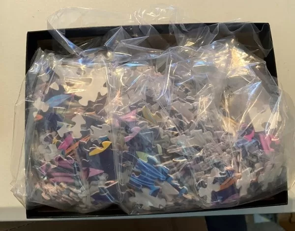
Jigsaw Puzzle (520 Pieces)
Discover the charm of the past with Media Storehouse's Jigsaw Puzzle featuring an intricately detailed Ordnance Survey map of Totley, 1876. This captivating puzzle, drawn from the archives of Sheffield City Archives, offers a fascinating glimpse into the history of this charming town. With landmarks such as Old Hay Brook, Grove House, Crown Inn, Hillfoot, Totley Bents, and the Cricket Inn depicted, this puzzle is not only a fun and engaging activity, but also a great educational tool for history enthusiasts and puzzle lovers alike. Immerse yourself in the intricacies of the map's design, as you piece together the past of Totley, brought to you by Media Storehouse.
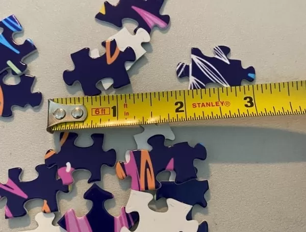
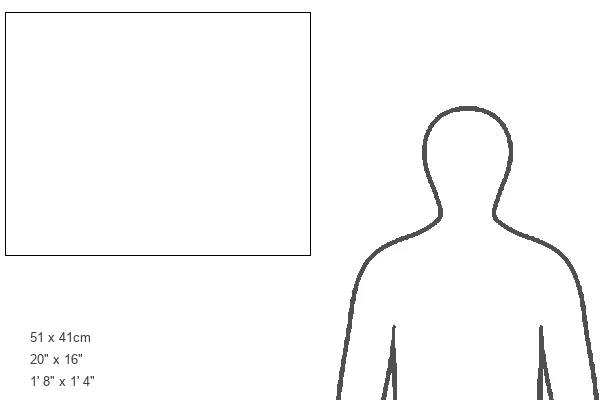
Made in the USA, 520-piece puzzles measure 16" x 20" (40.6 x 50.8 cm). Every puzzle is meticulously printed on glossy photo paper, which has a strong 1.33 mm thickness. Delivered in a black storage cardboard box, these puzzles are both stylish and practical. (Note: puzzles contain small parts and are not suitable for children under 3 years of age.)
Jigsaw Puzzles are an ideal gift for any occasion
Estimated Product Size is 50.8cm x 40.5cm (20" x 15.9")
These are individually made so all sizes are approximate
Artwork printed orientated as per the preview above, with landscape (horizontal) or portrait (vertical) orientation to match the source image.
FEATURES IN THESE COLLECTIONS
> Animals
> Insects
> Crickets
> House Cricket
> Animals
> Insects
> Hemiptera
> Green Scale
> Animals
> Insects
> Hemiptera
> Hall Scale
> Europe
> United Kingdom
> England
> Derbyshire
> Baslow
> Europe
> United Kingdom
> England
> Derbyshire
> Related Images
> Maps and Charts
> Related Images
> Sport
> Cricket
> Related Images
> Sheffield City Archives
> Maps and Plans
EDITORS COMMENTS
This print showcases an Ordnance Survey map of Totley from the year 1876. The intricate details and precision of this map are truly remarkable, providing a fascinating glimpse into the past. With a scale of 25 inches to 1 mile, every street, lane, and road is meticulously documented. The map highlights various landmarks and points of interest within Totley's boundaries. From the Old Hay Brook to Grove House, Crown Inn to Hillfoot, all these locations are etched onto this historical piece. Notably featured are popular establishments such as Cricket Inn and Fleur de Lis Public House, which were undoubtedly bustling with activity during that era. In addition to public houses and hotels, the map also pinpoints essential community facilities like schools and churches. Both Infants School and Boys and Girls School can be spotted on this detailed representation alongside Wesleyan Methodist Chapel. As we explore further into Totley's landscape through this photograph, we encounter names like Needhams Dike, Sunnybrook, Cross Scythes Public House, Totley Hall Farm - all contributing to the rich tapestry of life in this vibrant village. Preserved at Sheffield Local Studies Library under Derbyshire sheet XI. 15. , this invaluable artifact allows us to appreciate how much has changed over time while cherishing our heritage. Let us delve deep into history by examining these old roads like Baslow Road or Street Lane or discovering hidden gems such as Overcroft Rise or Stocks Green Drive
MADE IN THE USA
Safe Shipping with 30 Day Money Back Guarantee
FREE PERSONALISATION*
We are proud to offer a range of customisation features including Personalised Captions, Color Filters and Picture Zoom Tools
SECURE PAYMENTS
We happily accept a wide range of payment options so you can pay for the things you need in the way that is most convenient for you
* Options may vary by product and licensing agreement. Zoomed Pictures can be adjusted in the Cart.

![Map of Woodthorpe Hall Farm [Holmesfield] in the parish of Dronfield, County of Derby, 1736](/sq/716/map-woodthorpe-hall-farm-holmesfield-parish-18987347.jpg.webp)