Fraud Blocker Skip to main content

Map Making Collection (#14)

"Unveiling the Art of Map Making: A Journey Through Time and Space" Step into a world where cartography becomes an art form

Background imageMap Making Collection: Map of the Paris Universal Exposition, 1900

Map of the Paris Universal Exposition, 1900. More than 50 million people attended the exposition, designed to celebrate the achievements of the 19th century

Background imageMap Making Collection: Map of Alexandria, Egypt, 17th century

Map of Alexandria, Egypt, 17th century

Background imageMap Making Collection: Measuring the distance of an inaccessible object by triangulation using a hinged staff, 1617-1619

Measuring the distance of an inaccessible object by triangulation using a hinged staff, 1617-1619. From Utriusque cosmi...historia by Robert Fludd. (Oppenheim, 1617-1619)

Background imageMap Making Collection: Reiner Gemma Frisius, Dutch astronomer, geographer, cartographer and mathematician, 1539

Reiner Gemma Frisius, Dutch astronomer, geographer, cartographer and mathematician, 1539. Gemma Frisius (1508-1555) holding an adjustable ring dial for determining the altitude of the Sun for

Background imageMap Making Collection: Use of the magnetic compass in map making, 1643

Use of the magnetic compass in map making, 1643. Diagram of the use of the compass by cartographers and surveyors. Bor (Borealis) is north and Aust (Australis) is south

Background imageMap Making Collection: James Rennell, British geographer, 1802

James Rennell, British geographer, 1802. Rennell (1742-1839) was appointed the first surveyor-general of Bengal in 1764. He carried out a survey of Bengal 1765-1771. From The European Magazine

Background imageMap Making Collection: Dorothea Klumpke Roberts, American mathematician and astronomer, 1903

Dorothea Klumpke Roberts, American mathematician and astronomer, 1903. Roberts (1861-1942) at work on the Carte du Ciel at the Paris Observatory

Background imageMap Making Collection: Satellite photograph of Great Namaland, Namibia, 1972

Satellite photograph of Great Namaland, Namibia, 1972. Photographed by Landsat 1. The satellites multispectral scanner reveals lithologic and structural features with clarity

Background imageMap Making Collection: Death Valley, California, USA, 1982-1993

Death Valley, California, USA, 1982-1993. First full scene from the Thematic Mapper on Landsat 4. The vegetation-sparse terrain is dominated by landforms and other geological features

Background imageMap Making Collection: Map showing the supposed location of Paradise

Map showing the supposed location of Paradise. The Garden of Eden is represented by the blue-tinted quadrant. After an engraving of 1678 from a work by Johann Herbinius (1633-1676)

Background imageMap Making Collection: Map of stellar constellations, 1775

Map of stellar constellations, 1775. Constellations of Perseus carrying the head of Medusa, Andromeda chained to a rock, and the Triangle (Triangulum)

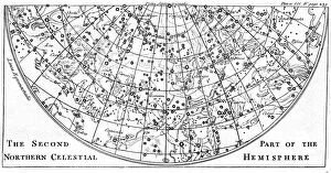
Background imageMap Making Collection: Second part of the star chart of the Northern Celestial Hemisphere showing constellations, 1747

Second part of the star chart of the Northern Celestial Hemisphere showing constellations, 1747

Background imageMap Making Collection: Part of the lunar surface, 1857

Part of the lunar surface, 1857. The surface of the Moon in the region of Mare Crisium at Old Moon. From Astronomical Observations made at the Royal Observatory, Edinburgh. (Edinburgh, 1857)

Background imageMap Making Collection: Title page of Isagoge in Typum Cosmographicum seu Mappam Mundi by Peter Apian, 1523

Title page of Isagoge in Typum Cosmographicum seu Mappam Mundi by Peter Apian, 1523. The page is illustrated with a map, centred on the Mediterranean, showing only three continents, Europe

Background imageMap Making Collection: Chinese map of the World including information taken to China by the Jesuit missionaries

Chinese map of the World including information taken to China by the Jesuit missionaries. Based on Matteo Riccis lost map of 1584

Background imageMap Making Collection: Anglo-Saxon world map, 10th century

Anglo-Saxon world map, 10th century. A map showing a flat Earth and the ocean that was thought to surround it. From the British Museum

Background imageMap Making Collection: French Map of Central and South America, French, 1550

French Map of Central and South America, French, 1550. Map showing Florida, the Gulf of Mexico, the Caribbean islands and Antilles, and South America with the River Plate prominent

Background imageMap Making Collection: Map by Bastian Lopez showing Europe, the British Isles and part of Africa, Portuguese, 1558

Map by Bastian Lopez showing Europe, the British Isles and part of Africa, Portuguese, 1558. Artist: Bastiaim Lopez
Map by Bastian Lopez showing Europe, the British Isles and part of Africa, Portuguese, 1558. From the British Museum

Background imageMap Making Collection: Map of Barbados, 1683

Map of Barbados, 1683. Barbados was first settled by the British in 1627. From the British Museum

Background imageMap Making Collection: Map of the east coast of North America, early 16th century

Map of the east coast of North America, early 16th century. Map of pre-1547 based on Jacques Cartiers discoveries of 1534-1541

Background imageMap Making Collection: Map of Brazil by Portuguese navigators Pedro Reinel and Lopo Homen, c1525. Artist: Pedro Reinel

Map of Brazil by Portuguese navigators Pedro Reinel and Lopo Homen, c1525. Artist: Pedro Reinel
Map of Brazil by Portuguese navigators Pedro Reinel and Lopo Homen, c1525

Background imageMap Making Collection: Part of South America, 1582

Part of South America, 1582. A Spanish map, showing the Amazon and the River Plate

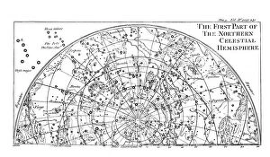
Background imageMap Making Collection: First part of the star chart of the Northern Celestial Hemisphere showing constellations, 1747

First part of the star chart of the Northern Celestial Hemisphere showing constellations, 1747

Background imageMap Making Collection: Second part of the star chart of the Southern Celestial Hemisphere showing constellations, 1747

Second part of the star chart of the Southern Celestial Hemisphere showing constellations, 1747

Background imageMap Making Collection: First part of the star chart of the Southern Celestial Hemisphere showing constellations, 1747

First part of the star chart of the Southern Celestial Hemisphere showing constellations, 1747

Background imageMap Making Collection: John Speed (1542-1629), English cartographer and historian, 1816

John Speed (1542-1629), English cartographer and historian, 1816. Speed is probably the most famous of British mapmakers. In 1612 he published The Theatre of the Empire of Great Britain

Background imageMap Making Collection: Early map of Massachusetts Bay, USA

Early map of Massachusetts Bay, USA. Massachusetts was first settled by the Pilgrim Fathers, the Puritans who escaped religious persecution in England and sailed to America from Plymouth, England

Background imageMap Making Collection: Cartographer at Work (pen and ink)

Cartographer at Work (pen and ink)
XJF701469 Cartographer at Work (pen and ink) by European School, (17th century); Private Collection; out of copyright

Background imageMap Making Collection: Trade card for Bernard Lens III, engraved by Louis Philippe Boitard (engraving)

Trade card for Bernard Lens III, engraved by Louis Philippe Boitard (engraving)
XJF400674 Trade card for Bernard Lens III, engraved by Louis Philippe Boitard (engraving) by Lens, Bernard III (1682-1740) (after); Private Collection; (add.info.: Mr)

Background imageMap Making Collection: Unlabelled globe

Unlabelled globe

Background imageMap Making Collection: Earths celestial circles, 1708 artwork

Earths celestial circles, 1708 artwork
The Earth and its celestial circles. This artwork is from the 1708 edition of the star atlas Harmonica Macrocosmica, by the Dutch-German mathematician and cosmographer Andreas Cellarius (1596-1665)


All Professionally Made to Order for Quick Shipping

"Unveiling the Art of Map Making: A Journey Through Time and Space" Step into a world where cartography becomes an art form, as we explore the captivating realm of map making. From ancient marvels to modern masterpieces, these maps offer glimpses into different eras and regions, showcasing the evolution of this timeless craft. Travel back in time to the 13th century with "The Hereford Mappa Mundi, " a stunning medieval creation by Richard de Bello. This intricate masterpiece not only depicts geographical features but also incorporates religious symbolism, providing a unique insight into the beliefs and knowledge of that era. Fast forward to British South Africa in 1900, where an unknown creator crafted the "General Map of British South Africa. " With meticulous detail, it showcases vast landscapes and settlements during this pivotal period in history. Venture eastward to Japan through two enigmatic maps from 1903. The first reveals Japan's provinces during Iyeyasu's reign while the second portrays feudal Japan before Sekigahara. Though their creators remain anonymous, these maps offer valuable insights into Japanese history and territorial divisions. Closer to home lies John Bartholomew's artistic rendition of Isle of Wight from the early 20th century. His skillful brushstrokes bring life to this picturesque island off England's southern coast, capturing its beauty for generations to come. Delve further into historical cartography with John Ogilby and William Morgan's collaborative effort on "Map of Essex" from 1678. Their detailed work provides a glimpse into English county boundaries during that time period. Crossing oceans brings us to Martinique in the late 18th century with a map dating back to around 1783. This Caribbean gem is meticulously depicted on paper—a testament to both exploration and colonial influence during that era.