Framed Print > Europe > Russia > Maps
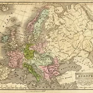
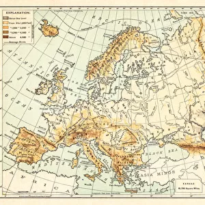
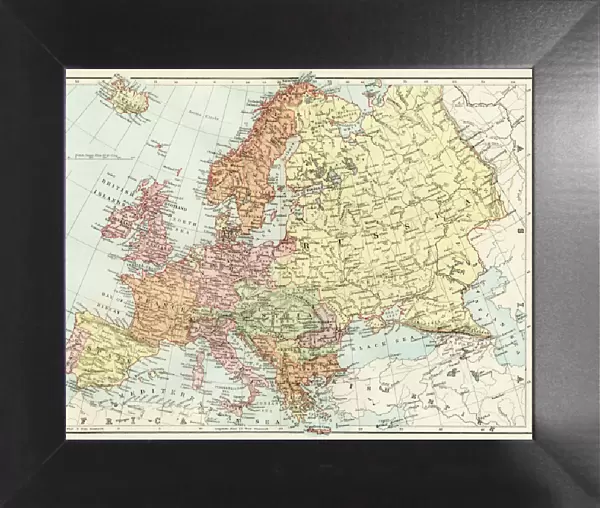
Framed Print : Map of Europe, 1870s


![]()
Framed Photos from North Wind
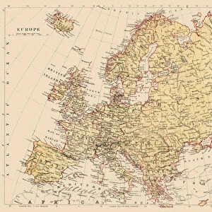
Map of Europe, 1870s
Map of Europe in the 1870s.
Color lithograph reproduction of a 19th-century illustration
North Wind Picture Archives brings history to life with stock images and hand-colored illustrations
Media ID 5882054
© North Wind Picture Archives
12"x10" Modern Frame
Discover the rich history of Europe in the 1870s with our exquisite Framed Prints from Media Storehouse. This captivating Map of Europe, sourced from the North Wind Picture Archives, is a stunning color lithograph reproduction of a 19th-century illustration. Transport yourself back in time as you explore the intricate details of Europe's borders and territories during an era of significant change. Each print is meticulously framed to preserve its vintage charm and add a touch of history to your home or office. Bring the past to life with our authentic, museum-quality reproductions.
10x8 Print in an MDF Wooden Frame with 180 gsm Satin Finish Paper. Glazed using shatter proof thin plexi glass. Frame thickness is 1 inch and depth 0.75 inch. Fluted cardboard backing held with clips. Supplied ready to hang with sawtooth hanger and rubber bumpers. Spot clean with a damp cloth. Packaged foam wrapped in a card.
Contemporary Framed and Mounted Prints - Professionally Made and Ready to Hang
Estimated Image Size (if not cropped) is 25.4cm x 25.4cm (10" x 10")
Estimated Product Size is 30.5cm x 25.4cm (12" x 10")
These are individually made so all sizes are approximate
Artwork printed orientated as per the preview above, with landscape (horizontal) or portrait (vertical) orientation to match the source image.
FEATURES IN THESE COLLECTIONS
> Europe
> Russia
> Related Images
> Maps and Charts
> Related Images
> North Wind Picture Archives
> Maps
EDITORS COMMENTS
This print showcases a remarkable piece of history - the Map of Europe in the 1870s. With its vibrant colors and intricate details, this color lithograph reproduction transports us back to a bygone era. The map itself is a testament to the rich heritage and traditional roots that define Europe. As we gaze upon this vintage illustration, our eyes are immediately drawn to Russia, which looms large on the map. Its vast expanse stretches across much of Eastern Europe, reminding us of its significant influence during this period. Surrounding countries such as Germany, France, Austria-Hungary, and Italy are also prominently featured with their distinct borders and territories. Every inch of this historic artwork tells a story about the political landscape and shifting alliances that characterized 19th-century Europe. It serves as an invaluable resource for historians and enthusiasts alike who seek to understand how nations evolved over time. The artistry behind this illustration is truly exceptional; it captures both accuracy and beauty simultaneously. The delicate lines and careful shading bring each country's shape to life while maintaining an overall sense of harmony within the composition. Whether you have an affinity for cartography or simply appreciate fine art from the 1800s, this Map of Europe from North Wind Picture Archives will undoubtedly captivate your imagination. Let it transport you back in time as you explore the intricacies of European history through this stunning visual representation.
MADE IN THE USA
Safe Shipping with 30 Day Money Back Guarantee
FREE PERSONALISATION*
We are proud to offer a range of customisation features including Personalised Captions, Color Filters and Picture Zoom Tools
SECURE PAYMENTS
We happily accept a wide range of payment options so you can pay for the things you need in the way that is most convenient for you
* Options may vary by product and licensing agreement. Zoomed Pictures can be adjusted in the Cart.