Fine Art Print > Maps and Charts > Africa
Fine Art Print : Map of the Old Continent (Europe, Africa, Asia)
")

![]()
Fine Art Prints from Mary Evans Picture Library
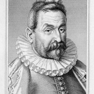
Map of the Old Continent (Europe, Africa, Asia)
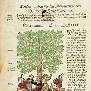
Map of the Old Continent (Europe, Africa, Asia). Engraving by J. vander Schley, from Pierre de Hondt, Histoire Naturelle generale et particuliere avec la description du Cabinet du Roy. Frontispiece to first discourse ( premier discours ). Date: 1750
Mary Evans Picture Library makes available wonderful images created for people to enjoy over the centuries
Media ID 10290395
© Mary Evans Picture Library 2015 - https://copyrighthub.org/s0/hub1/creation/maryevans/MaryEvansPictureID/10972047
1750 Avec Cabinet Continent Description Discourse Frontispiece Generale Histoire Hondt Naturelle Particuliere Pierre Premier Schley Vander Discours
20"x16" (+3" Border) Fine Art Print
Discover the rich history and cultural diversity of the Old Continent with our exquisite Fine Art Prints from Media Storehouse. This captivating map, originally engraved by J. vander Schley from Pierre de Hondt's Histoire Naturelle generale et particuliere, showcases Europe, Africa, and Asia in intricate detail. Bring the grandeur of the past into your home or office with this stunning, rights-managed print from Mary Evans Prints Online. Perfect for history enthusiasts, world travelers, or anyone seeking to add a touch of timeless elegance to their space.
20x16 image printed on 26x22 Fine Art Rag Paper with 3" (76mm) white border. Our Fine Art Prints are printed on 300gsm 100% acid free, PH neutral paper with archival properties. This printing method is used by museums and art collections to exhibit photographs and art reproductions.
Our fine art prints are high-quality prints made using a paper called Photo Rag. This 100% cotton rag fibre paper is known for its exceptional image sharpness, rich colors, and high level of detail, making it a popular choice for professional photographers and artists. Photo rag paper is our clear recommendation for a fine art paper print. If you can afford to spend more on a higher quality paper, then Photo Rag is our clear recommendation for a fine art paper print.
Estimated Image Size (if not cropped) is 40.6cm x 50.8cm (16" x 20")
Estimated Product Size is 55.9cm x 66cm (22" x 26")
These are individually made so all sizes are approximate
Artwork printed orientated as per the preview above, with portrait (vertical) orientation to match the source image.
FEATURES IN THESE COLLECTIONS
> Maps and Charts
> Related Images
EDITORS COMMENTS
This stunning engraving, titled "Map of the Old Continent (Europe, Africa, Asia)" is a captivating representation of the world as known in the mid-18th century. The intricately detailed map, created by J. vander Schley for Pierre de Hondt's "Histoire Naturelle générale et particulière avec la description du Cabinet du Roy," serves as the frontispiece to the first discourse of this comprehensive natural history publication. Published in 1750, this map showcases Europe, Africa, and Asia in their entirety, providing a glimpse into the geographical knowledge of the time. The Old World is depicted with remarkable accuracy, considering the limitations of cartographic technology during the period. The intricate detailing of coastlines, borders, and topographical features is a testament to the skill and dedication of the engraver. The map is particularly noteworthy for its depiction of Africa, which was still largely unexplored and misunderstood by Europeans during this time. The map includes various speculations about the interior of the continent, reflecting the fascination and curiosity that drove European explorers to venture into the unknown. This map is a fascinating window into the past, offering insights into the geographical knowledge and perceptions of the Old World during the 18th century. Its intricate detailing and historical significance make it a valuable addition to any collection of historical maps or natural history publications.
MADE IN THE USA
Safe Shipping with 30 Day Money Back Guarantee
FREE PERSONALISATION*
We are proud to offer a range of customisation features including Personalised Captions, Color Filters and Picture Zoom Tools
SECURE PAYMENTS
We happily accept a wide range of payment options so you can pay for the things you need in the way that is most convenient for you
* Options may vary by product and licensing agreement. Zoomed Pictures can be adjusted in the Cart.