Canvas Print > Arts > Artists > W > Frederick de Wit
Canvas Print : Map of Europe, 1700


![]()
Canvas Prints from Science Photo Library
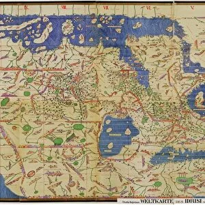
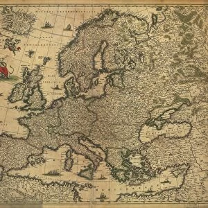
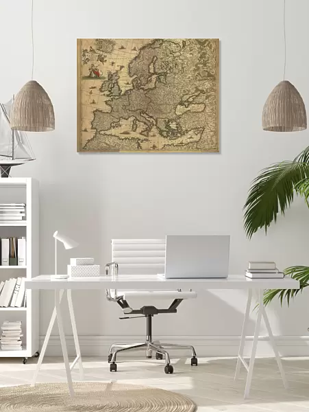
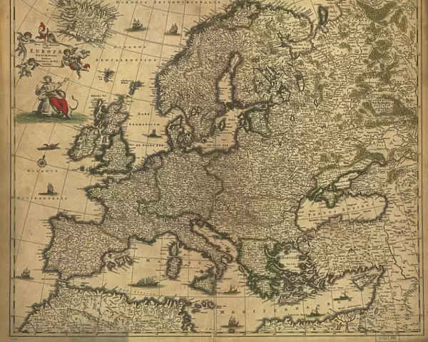
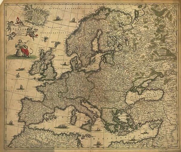
Map of Europe, 1700
17th century map of Europe. Published in 1700, this map by the Dutch cartographer Frederick de Witt (1630-1706) shows the latest knowledge of the geography of Europe. The mapping has improved greatly on earlier maps, though there are still errors and distortions of scale. The inscriptions are in Latin. The title banner at upper left is being carried by cherubs, and below that is a depiction of the mythological tale of Europa, carried away by Zeus who took the form of a white bull. The continent of Europe is named after Europa
Science Photo Library features Science and Medical images including photos and illustrations
Media ID 1699835
© LIBRARY OF CONGRESS, GEOGRAPHY AND MAP DIVISION/SCIENCE PHOTO LIBRARY
1600s 1700 1700s 17th Century 18th Century Age Of Discovery Bull Cartography Colonies Colony Dutch Empire Europa Exploration French Greek Mythology Latin Medieval Middle Ages Spanish De Wit Zeus
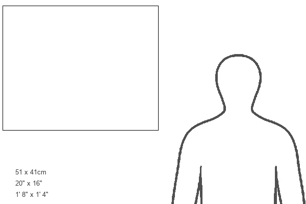
20"x16" (51x41cm) Canvas Print
Discover the rich history of Europe with our stunning Canvas Prints from Media Storehouse. This exquisite piece features the "Map of Europe, 1700" by Frederick de Witt, published by the Science Photo Library. Travel back in time to the 17th century and explore the latest geographical knowledge of Europe during this fascinating era. The intricate detail and vibrant colors bring the map to life, making it a captivating addition to any room. Perfect for history enthusiasts, cartography lovers, or anyone seeking to add a touch of the old world to their decor. Order your Canvas Print today and let the story of Europe unfold in your home.
Delivered stretched and ready to hang our premium quality canvas prints are made from a polyester/cotton blend canvas and stretched over a 1.25" (32mm) kiln dried knot free wood stretcher bar. Packaged in a plastic bag and secured to a cardboard insert for safe transit.
Canvas Prints add colour, depth and texture to any space. Professionally Stretched Canvas over a hidden Wooden Box Frame and Ready to Hang
Estimated Product Size is 50.8cm x 40.6cm (20" x 16")
These are individually made so all sizes are approximate
Artwork printed orientated as per the preview above, with landscape (horizontal) orientation to match the source image.
FEATURES IN THESE COLLECTIONS
> Arts
> Art Movements
> Medieval Art
> Arts
> Artists
> W
> Frederick de Wit
> Europe
> Greece
> Related Images
> Europe
> Spain
> Related Images
> Historic
> Ancient civilizations
> Ancient Greece
> Greek history
> Science Photo Library
> History
EDITORS COMMENTS
This print showcases a remarkable piece of history - a map of Europe from the 17th century, published in 1700 by the esteemed Dutch cartographer Frederick de Witt. With an unwavering commitment to accuracy, this map represents the latest knowledge of European geography at that time. De Witt's meticulous mapping skills have significantly improved upon earlier renditions, although some errors and distortions of scale still persist. The inscriptions on this masterpiece are elegantly written in Latin, adding an air of sophistication and authenticity to its composition. At the upper left corner, we find a striking title banner being carried by cherubs, symbolizing the importance and grandeur associated with Europe. Just below it lies a depiction of Europa's mythological tale - she was famously carried away by Zeus in the form of a white bull. It is worth noting that our beloved continent derives its name from her. As we delve into this extraordinary visual representation, we gain insight into not only European colonialism but also medieval history and exploration during the Age of Discovery. This map serves as a testament to De Witt's mastery in cartography while offering us glimpses into Spanish, French, and other empires that once shaped Europe's rich tapestry. With its fusion of artistry and scientific precision, this 17th-century map transports us back in time to an era where geographical knowledge was expanding rapidly. A true treasure for any history enthusiast or lover of ancient maps!
MADE IN THE USA
Safe Shipping with 30 Day Money Back Guarantee
FREE PERSONALISATION*
We are proud to offer a range of customisation features including Personalised Captions, Color Filters and Picture Zoom Tools
SECURE PAYMENTS
We happily accept a wide range of payment options so you can pay for the things you need in the way that is most convenient for you
* Options may vary by product and licensing agreement. Zoomed Pictures can be adjusted in the Cart.