Metal Print > Arts > Landscape paintings > Waterfall and river artworks > River artworks
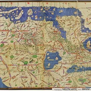
Metal Print : MAP OF LOUISIANA TERRITORY. Detail of a map of the Mississippi Valley and the Louisisana


![]()
Metal Prints from Granger
MAP OF LOUISIANA TERRITORY. Detail of a map of the Mississippi Valley and the Louisisana
MAP OF LOUISIANA TERRITORY.
Detail of a map of the Mississippi Valley and the Louisisana Territory made by Guillaume Delisle, Nuremberg, Germany, 1734
Granger holds millions of images spanning more than 25,000 years of world history, from before the Stone Age to the dawn of the Space Age
Media ID 12321078
1734 Colonial Guillaume Louisiana Louisiana Purchase Manifest Destiny Mississippi Mississippi River New France Territory United States Valley Westward Expansion Delisle Southeast
16"x20" (51x41cm) Metal Print
Discover the rich history of the Mississippi Valley and Louisiana Territory with our stunning Metal Prints from Media Storehouse. Featuring a captivating detail of a map created by Guillaume Delisle in 1734, this vintage cartography artwork showcases the intricate details of the region during an era of exploration and discovery. Our high-quality Metal Prints bring out the vibrant colors and intricate lines of the map, making it a beautiful addition to any home or office decor. Relive the past and add a touch of history to your space with this exquisite piece of art.
Made with durable metal and luxurious printing techniques, our metal photo prints go beyond traditional canvases, adding a cool, modern touch to your space. Wall mount on back. Eco-friendly 100% post-consumer recycled ChromaLuxe aluminum surface. The thickness of the print is 0.045". Featuring a Scratch-resistant surface and Rounded corners. Backing hangers are attached to the back of the print and float the print 1/2-inch off the wall when hung, the choice of hanger may vary depending on size and International orders will come with Float Mount hangers only. Finished with a brilliant white high gloss surface for unsurpassed detail and vibrance. Printed using Dye-Sublimation and for best care we recommend a non-ammonia glass cleaner, water, or isopropyl (rubbing) alcohol to prevent harming the print surface. We recommend using a clean, lint-free cloth to wipe off the print. The ultra-hard surface is scratch-resistant, waterproof and weatherproof. Avoid direct sunlight exposure.
Made with durable metal and luxurious printing techniques, metal prints bring images to life and add a modern touch to any space
Estimated Image Size (if not cropped) is 50.8cm x 40.6cm (20" x 16")
Estimated Product Size is 51.4cm x 41.2cm (20.2" x 16.2")
These are individually made so all sizes are approximate
Artwork printed orientated as per the preview above, with landscape (horizontal) orientation to match the source image.
FEATURES IN THESE COLLECTIONS
> Arts
> Landscape paintings
> Waterfall and river artworks
> River artworks
> Europe
> Germany
> Nuremberg
> Europe
> Germany
> Related Images
> Historic
> Colonial America illustrations
> Colonial America
> Maps and Charts
> Early Maps
EDITORS COMMENTS
This print showcases a detailed map of the Louisiana Territory, created by the talented cartographer Guillaume Delisle in 1734. The map provides an intricate depiction of the Mississippi Valley and the vast expanse of the Louisiana Territory, which was then under French control. With its precise lines and meticulous labeling, this historical artifact offers a glimpse into America's colonial past and early exploration efforts. It serves as a testament to the ambitions that shaped American history, such as manifest destiny and westward expansion. The significance of this map cannot be overstated, particularly due to its connection with one of America's most pivotal moments: the Louisiana Purchase. This acquisition from France in 1803 doubled the size of the United States overnight and paved the way for future growth and development. As we gaze upon this print, we are transported back in time to an era when New France still existed on North American soil. We can trace our fingers along the winding path of the mighty Mississippi River while imagining pioneers venturing into uncharted territories. Whether you are an avid history enthusiast or simply appreciate remarkable works of art, this print is sure to captivate your imagination with its rich historical context and visual splendor.
MADE IN THE USA
Safe Shipping with 30 Day Money Back Guarantee
FREE PERSONALISATION*
We are proud to offer a range of customisation features including Personalised Captions, Color Filters and Picture Zoom Tools
FREE COLORIZATION SERVICE
You can choose advanced AI Colorization for this picture at no extra charge!
SECURE PAYMENTS
We happily accept a wide range of payment options so you can pay for the things you need in the way that is most convenient for you
* Options may vary by product and licensing agreement. Zoomed Pictures can be adjusted in the Cart.