Home > Europe > France > Canton > Landes
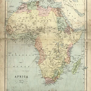
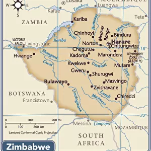
1780 Raynal And Bonne Map Of South Africa Zimbabwe

![]()
Wall Art and Photo Gifts from Universal Images Group (UIG)
1780 Raynal And Bonne Map Of South Africa Zimbabwe
1780, Raynal and Bonne Map of South Africa, Zimbabwe, Madagascar, and Mozambique, Rigobert Bonne 1727 - 1794, one of the most important cartographers of the late 18th century
Universal Images Group (UIG) manages distribution for many leading specialist agencies worldwide
Media ID 38548211
© Artokoloro Quint Lox Limited
1780 Madagascar Rigobert Bonne 1727 – 1794 Zimbabwe Antique Map Latitude Longitude Mappa Mundi Old Antique Plan Old Antique View Ols Antique Map Rare Old Maps Topo
FEATURES IN THESE COLLECTIONS
> Africa
> Madagascar
> Maps
> Africa
> Madagascar
> Related Images
> Africa
> Mozambique
> Maps
> Africa
> Mozambique
> Related Images
> Africa
> Related Images
> Africa
> South Africa
> Maps
> Africa
> South Africa
> Related Images
> Africa
> Zimbabwe
> Related Images
> Europe
> France
> Canton
> Landes
> Universal Images Group (UIG)
> History
> Historical Maps
EDITORS COMMENTS
Step back in time to the 18th century with this stunning print of a Raynal and Bonne map, showcasing the southeastern region of Africa. Created by renowned cartographer Rigobert Bonne in 1780, this vintage illustration is a testament to the meticulous attention to detail and artistic skill of its creator.
The map depicts South Africa, Zimbabwe, Madagascar, and Mozambique with remarkable accuracy, highlighting the topography and geography of each region. The intricate details include mountains, rivers, lakes, and cities, giving us a glimpse into the landscape as it was over two centuries ago.
This beautiful piece is not only a fascinating historical artifact but also an impressive work of art. The use of color and shading adds depth and texture to the image, making it almost three-dimensional. It's easy to get lost in the intricate patterns and lines that crisscross the page.
For anyone interested in history, geography or simply appreciating rare maps from another era, this print is a must-have addition to any collection. Its beauty lies not only in its historical significance but also in its ability to transport us back in time.
MADE IN THE USA
Safe Shipping with 30 Day Money Back Guarantee
FREE PERSONALISATION*
We are proud to offer a range of customisation features including Personalised Captions, Color Filters and Picture Zoom Tools
SECURE PAYMENTS
We happily accept a wide range of payment options so you can pay for the things you need in the way that is most convenient for you
* Options may vary by product and licensing agreement. Zoomed Pictures can be adjusted in the Cart.