Home > Arts > Artists > D > Charles Deas
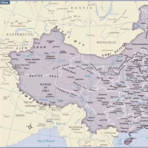
Map of Cathay, China, from Catalan Atlas created for Charles V, King of France, attributed to Abraham and Jafuda Cresques Maiorca, circa 1375

![]()
Wall Art and Photo Gifts from Universal Images Group (UIG)
Map of Cathay, China, from Catalan Atlas created for Charles V, King of France, attributed to Abraham and Jafuda Cresques Maiorca, circa 1375
Cartography, 14th century. Map of Cathay (China). From Catalan Atlas created for Charles V, King of France, attributed to Abraham and Jafuda Cresques Maiorca (circa 1375). Copy of the original located in Paris, at the National Library of France
Universal Images Group (UIG) manages distribution for many leading specialist agencies worldwide
Media ID 9571827
© DEA PICTURE LIBRARY
14th Century China Coastline Continent Peninsula Wind Rose Catalan Atlas Cathay Charles V
FEATURES IN THESE COLLECTIONS
> Arts
> Artists
> C
> Abraham Cresques
> Arts
> Artists
> C
> King Charles
> Arts
> Artists
> D
> Charles Deas
> Asia
> China
> Related Images
> Europe
> France
> Paris
> Maps
> Europe
> France
> Paris
> Related Images
> Universal Images Group (UIG)
> Art
> Painting, Sculpture & Prints
> Cartography
EDITORS COMMENTS
This print showcases a remarkable piece of cartographic history - the Map of Cathay, China. Created for Charles V, King of France, and attributed to Abraham and Jafuda Cresques Maiorca around 1375, this map is a testament to the skill and artistry of its creators. The Map of Cathay is part of the Catalan Atlas, which can be found in Paris at the National Library of France. It offers a fascinating glimpse into 14th-century geography and topography, depicting the vast continent with intricate detail. The vertical orientation adds an element of uniqueness to this masterpiece. One cannot help but marvel at how Abraham and Jafuda Cresques brought this ancient land to life through their illustration and painting techniques. With no human representation present on the map, it allows us to focus solely on its features - from coastlines that hug majestic peninsulas to wind roses indicating directions. As we explore every inch of this print, we are transported back in time when maps were not just tools for navigation but also works of art. The craftsmanship displayed here reflects both technical accuracy and artistic expression. This print serves as a reminder that even centuries ago, people had an insatiable curiosity about distant lands like Cathay (China). It invites us to appreciate the rich history behind cartography while igniting our own sense of wanderlust for exploration beyond borders.
MADE IN THE USA
Safe Shipping with 30 Day Money Back Guarantee
FREE PERSONALISATION*
We are proud to offer a range of customisation features including Personalised Captions, Color Filters and Picture Zoom Tools
SECURE PAYMENTS
We happily accept a wide range of payment options so you can pay for the things you need in the way that is most convenient for you
* Options may vary by product and licensing agreement. Zoomed Pictures can be adjusted in the Cart.