Home > Europe > United Kingdom > England > London > Boroughs > Ealing
Ealing UB6 9 Map

![]()
Wall Art and Photo Gifts from Map Marketing
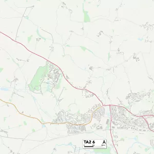
Ealing UB6 9 Map
Postcode Sector Map of Ealing UB6 9
Media ID 19979948
Allenby Road Andover Close Avon Road Beechwood Avenue Bingley Road Canterbury Close Chesterton Close Dacre Close Dale Road Ealing East Close Ellesmere Road Evesham Close Fisher Close Garrick Road Greenford Road Greenway Gardens Henley Close Keats Way Kings Avenue Lovell Road Lyndhurst Road Mansell Road Marley Close Melrose Avenue Melrose Close Mornington Road Nicholas Close Oldfield Lane Osborne Road Otter Road Pembroke Road Penn Close Portland Crescent Princes Avenue Purcell Road Queens Avenue Somerset Road Stanhope Road The Grove Warren Drive West Close Whittle Close Windmill Lane
FEATURES IN THESE COLLECTIONS
> Animals
> Mammals
> Bovidae
> Goral
> Europe
> United Kingdom
> England
> Avon
> Europe
> United Kingdom
> England
> London
> Boroughs
> Ealing
> Europe
> United Kingdom
> England
> Middlesex
> Related Images
> Europe
> United Kingdom
> England
> Somerset
> Greenway
> Europe
> United Kingdom
> England
> Somerset
> Henley
> Europe
> United Kingdom
> England
> Somerset
> Related Images
> Europe
> United Kingdom
> Scotland
> Scottish Borders
> Melrose
> Europe
> United Kingdom
> Wales
> Pembrokeshire
> Pembroke
> Map Marketing
> Postcode Sector Maps
> UB - Uxbridge
> Maps and Charts
> Related Images
MADE IN THE USA
Safe Shipping with 30 Day Money Back Guarantee
FREE PERSONALISATION*
We are proud to offer a range of customisation features including Personalised Captions, Color Filters and Picture Zoom Tools
SECURE PAYMENTS
We happily accept a wide range of payment options so you can pay for the things you need in the way that is most convenient for you
* Options may vary by product and licensing agreement. Zoomed Pictures can be adjusted in the Cart.