Home > Europe > United Kingdom > Scotland > Dumfries and Galloway > Thornhill
Solihull B91 2 Map

![]()
Wall Art and Photo Gifts from Map Marketing
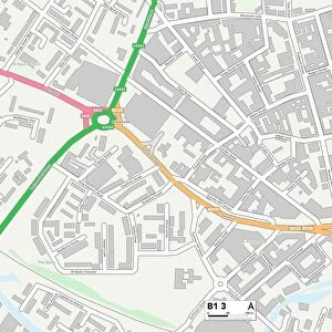
Solihull B91 2 Map
Postcode Sector Map of Solihull B91 2
Media ID 19966240
Alston Road Anchor Lane Beauchamp Road Boulton Road Bourne Close Brandon Road Catherines Close Dovecote Close Elms Close Ferndown Road Field Lane Glebe Road Grove Avenue Grove Road Hampton Lane Heath Gardens Heath Road Heather Grove Heaton Road Hermitage Road Links Drive Manor Road Marsh Lane Moat Lane Naseby Road Newfield Close Oakland Close Orchard Avenue Pinfold Road Ratcliffe Road Redlands Road School Lane Solihull St Helens Road The Green Thornhill Road Union Road Vulcan Road Warwick Road Wharf Lane Willow Crescent Woodfield Road Yew Tree Lane
FEATURES IN THESE COLLECTIONS
> Animals
> Mammals
> Muridae
> Heath Mouse
> Europe
> United Kingdom
> Scotland
> Dumfries and Galloway
> Thornhill
> Map Marketing
> Postcode Sector Maps
> B - Birmingham
> Maps and Charts
> Related Images
> Maps and Charts
> Star Charts
MADE IN THE USA
Safe Shipping with 30 Day Money Back Guarantee
FREE PERSONALISATION*
We are proud to offer a range of customisation features including Personalised Captions, Color Filters and Picture Zoom Tools
SECURE PAYMENTS
We happily accept a wide range of payment options so you can pay for the things you need in the way that is most convenient for you
* Options may vary by product and licensing agreement. Zoomed Pictures can be adjusted in the Cart.