Home > Europe > France > Maps
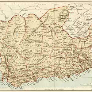
Lourenco-Marques; Afrique Australe, 1914. Creator: Unknown

![]()
Wall Art and Photo Gifts from Heritage Images
Lourenco-Marques; Afrique Australe, 1914. Creator: Unknown
Lourenco-Marques; Afrique Australe, 1914. From "Grande Geographie Bong Illustree", 1914
Heritage Images features heritage image collections
Media ID 36296917
© The Print Collector/Heritage Images
Cartography Map Making Mapmaking
FEATURES IN THESE COLLECTIONS
> Maps and Charts
> Related Images
EDITORS COMMENTS
This photograph print, titled "Lourenco-Marques; Afrique Australe" and dated 1914, is an intriguing glimpse into the past of cartography and the exploration of Africa. The image is taken from the pages of "Grande Geographie Illustree," a renowned French geography publication of the time. The photograph showcases an exquisitely detailed map of the southernmost part of Africa, with a particular focus on the region now known as Maputo, Mozambique, then named Lourenco-Marques. The map is rendered in vibrant colors, with borders delineating various European colonies and territories, as well as native African kingdoms and territories. The intricate detailing of the map reflects the extensive knowledge and exploration that had taken place in Africa during the late 19th and early 20th centuries. The French influence is evident in the map, with French territories prominently marked. The map also includes an inset of Madagascar, another French colony, further highlighting the French interest in the region. The mapmaking techniques of the time, such as the use of topographical features, rivers, and coastlines, are evident in the print. This photograph print is a testament to the rich history of cartography and the exploration of Africa during the 20th century. It offers a unique perspective into the geographical knowledge of the time and the political landscape of the African continent during the era of European colonization. The print's unknown creator remains a mystery, but their work continues to provide valuable insights into the past and the evolution of geographical knowledge.
MADE IN THE USA
Safe Shipping with 30 Day Money Back Guarantee
FREE PERSONALISATION*
We are proud to offer a range of customisation features including Personalised Captions, Color Filters and Picture Zoom Tools
SECURE PAYMENTS
We happily accept a wide range of payment options so you can pay for the things you need in the way that is most convenient for you
* Options may vary by product and licensing agreement. Zoomed Pictures can be adjusted in the Cart.