Home > Africa > South Africa > Maps
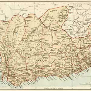
Depressoin du Ngami Kalahari; Afrique Australe, 1914. Creator: Unknown

![]()
Wall Art and Photo Gifts from Heritage Images
Depressoin du Ngami Kalahari; Afrique Australe, 1914. Creator: Unknown
Depressoin du Ngami Kalahari; Afrique Australe, 1914. From "Grande Geographie Bong Illustree", 1914
Heritage Images features heritage image collections
Media ID 36296735
© The Print Collector/Heritage Images
Cartography Geological Map Map Making Mapmaking South Africa Bechuanaland
FEATURES IN THESE COLLECTIONS
> Africa
> South Africa
> Maps
> Africa
> South Africa
> Related Images
> Maps and Charts
> Geological Map
> Maps and Charts
> Related Images
Depression du Ngami Kalahari; Afrique Australe
EDITORS COMMENTS
is an intriguing and captivating geographical map print from the early 20th century, specifically from the year 1914. The creator of this masterpiece remains unknown, but it was published in the renowned French geographical magazine "Grande Geographie Bong Illustree." The map provides a detailed and colorful representation of the southern African region, with a particular focus on the Ngami Depression in what is now known as Botswana and northern South Africa. The mapmaking techniques employed during this era are evident in the meticulous depiction of topographical features, including rivers, mountains, and bodies of water. At the time, this region was known as Bechuanaland, a territory under British protection. The map reflects the European exploration and cartographic efforts in Africa during the late 19th and early 20th centuries. The map's title, "Depression du Ngami Kalahari; Afrique Australe," translates to "Ngami Depression, Southern Africa," highlighting the geographical significance of this area. The map's vibrant colors and detailed illustrations transport us back in time, allowing us to appreciate the historical context of European exploration and mapping of the African continent. The map's age and the mystery surrounding its creator add to its allure, making it a valuable addition to any collection focused on cartography, African history, or geography. This print is a testament to the rich history of mapmaking and the European fascination with exploring and understanding the world around them. It serves as a reminder of the importance of preserving historical documents and the stories they hold, allowing future generations to learn from the past and appreciate the evolution of cartography and geographical knowledge.
MADE IN THE USA
Safe Shipping with 30 Day Money Back Guarantee
FREE PERSONALISATION*
We are proud to offer a range of customisation features including Personalised Captions, Color Filters and Picture Zoom Tools
SECURE PAYMENTS
We happily accept a wide range of payment options so you can pay for the things you need in the way that is most convenient for you
* Options may vary by product and licensing agreement. Zoomed Pictures can be adjusted in the Cart.