Home > Europe > France > Maps
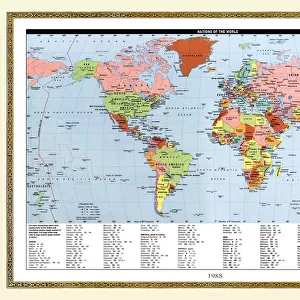
Carte des bassins miniers et des usines metallurgiques de la Lorraine et de la Sarre, 1916. Creator: Unknown

![]()
Wall Art and Photo Gifts from Heritage Images
Carte des bassins miniers et des usines metallurgiques de la Lorraine et de la Sarre, 1916. Creator: Unknown
Carte des bassins miniers et des usines metallurgiques de la Lorraine et de la Sarre. 1916. From "Collection de la Guerre IV. L'Illustration Tome CXLVII. La Guerre Juillet, Aout, Septembre, Octobre, Novembre, Decembre 1916"
Heritage Images features heritage image collections
Media ID 36338825
© The Print Collector/Heritage Images
Cartography Lillustration Lorraine France Map Making Mapmaking
FEATURES IN THESE COLLECTIONS
> Historic
> World War I and II
> World War I
> Historic
> World War I and II
> Maps and Charts
> Related Images
> Maps and Charts
> World
Carte des bassins miniers et des usines metallurgiques de la Lorraine et de la Sarre
EDITORS COMMENTS
is a historic black and white map print from 1916, depicting the mining and metallurgical industries in Lorraine and Sarre regions of France during the First World War. The map provides an intricate and detailed representation of the locations of various mines and metallurgical plants, highlighting the extensive industrial activity in the area during that period. The map is a significant historical document, offering insights into the strategic importance of the mining and metallurgical industries in the context of the First World War. Lorraine and Sarre, located in northeastern France, were rich in natural resources, particularly coal and iron ore, which were essential for the production of steel and other metals used in the war effort. The map reflects the intense industrialization of the region, with numerous mines and factories marked, indicating the significant economic and military value of the area. The map was published in "Collection de la Guerre IV. L'Illustration Tome CXLVII. La Guerre Juillet, Aout, Septembre, Octobre, Novembre, Decembre 1916," a publication that documented the events of the First World War. The map's inclusion in this publication underscores its significance as a historical record of the war and the industrial activity in the Lorraine and Sarre regions during that time. Despite the map's historical importance, the creator remains unknown. The map's intricate detail and accuracy suggest the work of a skilled cartographer or mapmaker. The map's age and lack of identifying marks make it a fascinating mystery, adding to its historical value and allure. Overall, this historic map print offers a unique glimpse into the industrial landscape of France during the First World War and the strategic role of the Lorraine and Sarre regions in the war effort.
MADE IN THE USA
Safe Shipping with 30 Day Money Back Guarantee
FREE PERSONALISATION*
We are proud to offer a range of customisation features including Personalised Captions, Color Filters and Picture Zoom Tools
FREE COLORIZATION SERVICE
You can choose advanced AI Colorization for this picture at no extra charge!
SECURE PAYMENTS
We happily accept a wide range of payment options so you can pay for the things you need in the way that is most convenient for you
* Options may vary by product and licensing agreement. Zoomed Pictures can be adjusted in the Cart.