Home > Animals > Mammals > Bovidae > Beira
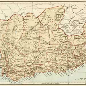
Beira. Sofala; Afrique Australe, 1914. Creator: Unknown

![]()
Wall Art and Photo Gifts from Heritage Images
Beira. Sofala; Afrique Australe, 1914. Creator: Unknown
Beira. Sofala; Afrique Australe, 1914. From "Grande Geographie Bong Illustree", 1914
Heritage Images features heritage image collections
Media ID 36296921
© The Print Collector/Heritage Images
Cartography Map Making Mapmaking
FEATURES IN THESE COLLECTIONS
> Animals
> Mammals
> Bovidae
> Beira
> Maps and Charts
> Related Images
Beira, Sofala; Afrique Australe, 1914
EDITORS COMMENTS
is an intriguing and historically significant map print that offers a glimpse into the cartographic exploration of Africa during the early 20th century. The creator of this map is unknown, but it was published in the renowned French geographical journal "Grande Geographie Illustree" in 1914. The map depicts the eastern coast of Africa, with a particular focus on the region surrounding the port city of Beira in the Sofala province of present-day Mozambique. At the time, this area was a French protectorate, and the map reflects the French influence and interest in the region. The map is striking for its vibrant colors and detailed illustrations of the topography, including mountains, rivers, and bodies of water. The use of color coding to differentiate various territories and political divisions is also noteworthy, reflecting the evolving cartographic techniques of the time. The mapmaking process during the 1900s was a critical period in the exploration and colonization of Africa. European powers, including France, were actively competing for territorial claims and economic resources, and maps played a crucial role in this process. Accurate and detailed maps were essential for navigation, military strategy, and administrative control. The "Beira, Sofala; Afrique Australe, 1914" map is a testament to the rich history of cartography and the role it played in shaping our understanding of the world. Despite being over a century old, this map continues to capture the imagination and fascination of historians, geographers, and collectors alike, offering a unique window into the past and the ongoing story of human exploration and discovery.
MADE IN THE USA
Safe Shipping with 30 Day Money Back Guarantee
FREE PERSONALISATION*
We are proud to offer a range of customisation features including Personalised Captions, Color Filters and Picture Zoom Tools
SECURE PAYMENTS
We happily accept a wide range of payment options so you can pay for the things you need in the way that is most convenient for you
* Options may vary by product and licensing agreement. Zoomed Pictures can be adjusted in the Cart.