Fraud Blocker Skip to main content

Navigational Equipment Collection (#5)

"Unveiling the Past: Navigational Equipment Guides Us Through History" Exploring ancient civilizations

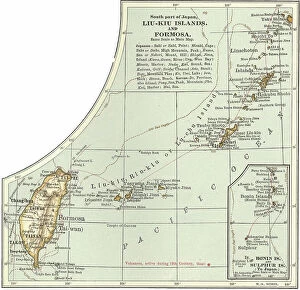
Background imageNavigational Equipment Collection: Map of the Liu-Kiu Islands and Formosa, c.1900 (engraving)

Map of the Liu-Kiu Islands and Formosa, c.1900 (engraving)
533335 Map of the Liu-Kiu Islands and Formosa, c.1900 (engraving); (add.info.: Historical map of Southern part of Japan, Liu-Kiu Islands and Formosa with inset map of Bonin and Sulphur Islands)

Background imageNavigational Equipment Collection: Map of Naples, c.1900 (engraving)

Map of Naples, c.1900 (engraving)
533313 Map of Naples, c.1900 (engraving); (add.info.: Map of Naples, Italy, circa 1902, from the 10th edition of Encyclopaedia Britannica.); Encyclopaedia Britannica/UIG

Background imageNavigational Equipment Collection: Map of Kristianiafjord, Kristiania, c.1900 (engraving)

Map of Kristianiafjord, Kristiania, c.1900 (engraving)
533309 Map of Kristianiafjord, Kristiania, c.1900 (engraving); (add.info.: Map of Kristiania (now Oslo), Norway, circa 1902

Background imageNavigational Equipment Collection: Map of the Canary Islands, c.1900 (engraving)

Map of the Canary Islands, c.1900 (engraving)
533299 Map of the Canary Islands, c.1900 (engraving); (add.info.: Map of Canary Islands (Spanish), circa 1902, from the 10th edition of Encyclopaedia Britannica.); Encyclopaedia Britannica/UIG

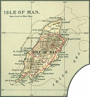
Background imageNavigational Equipment Collection: Map of the Isle of Man, c.1900 (engraving)

Map of the Isle of Man, c.1900 (engraving)
533276 Map of the Isle of Man, c.1900 (engraving); (add.info.: Map of Isle of Man, United Kingdom, circa 1902, from the 10th edition of Encyclopaedia Britannica.); Encyclopaedia Britannica/UIG

Background imageNavigational Equipment Collection: Map of Russia showing historical boundaries of Russia in Europe with Poland and Finland, circa 1902

Map of Russia showing historical boundaries of Russia in Europe with Poland and Finland, circa 1902
532992 Map of Russia showing historical boundaries of Russia in Europe with Poland and Finland, circa 1902; (add.info.: Map showing historical boundaries of Russia in Europe with Poland and Finland)

Background imageNavigational Equipment Collection: Map of Italy with Sicily and Naples, c.1900 (engraving)

Map of Italy with Sicily and Naples, c.1900 (engraving)
532989 Map of Italy with Sicily and Naples, c.1900 (engraving); (add.info.: Map of central and southern Italy with insets map of Sicily and Naples, circa 1902)

Background imageNavigational Equipment Collection: Map of Denmark, c.1900 (engraving)

Map of Denmark, c.1900 (engraving)
532967 Map of Denmark, c.1900 (engraving); (add.info.: Map of Denmark, with insets of Iceland, Copenhagen, and the Faeroe Islands, circa 1902)

Background imageNavigational Equipment Collection: Map of Wisconsin, c.1900 (engraving)

Map of Wisconsin, c.1900 (engraving)
533185 Map of Wisconsin, c.1900 (engraving); (add.info.: Map of Wisconsin, United States, with an inset map of Milwaukee and the Waukesha Lake Region, circa 1902)

Background imageNavigational Equipment Collection: Map of the northern part of Michigan, c.1900 (engraving)

Map of the northern part of Michigan, c.1900 (engraving)
533181 Map of the northern part of Michigan, c.1900 (engraving); (add.info.: Map of the northern part of Michigan, United States, with inset maps of St)

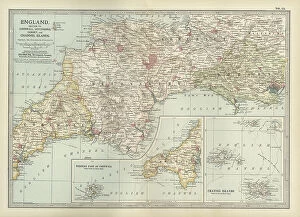
Background imageNavigational Equipment Collection: Map of England, c.1900 (engraving)

Map of England, c.1900 (engraving)
532930 Map of England, c.1900 (engraving); (add.info.: Map of England, with Cornwall, Devonshire, Dorset, and an inset of the Channel Islands, circa 1902)

Background imageNavigational Equipment Collection: Map of southern Ohio, c.1900 (engraving)

Map of southern Ohio, c.1900 (engraving)
533168 Map of southern Ohio, c.1900 (engraving); (add.info.: Map of the southern part of Ohio, United States, with inset maps of Cincinnati and Cleveland, circa 1902)

Background imageNavigational Equipment Collection: Map of England, c.1900 (engraving)

Map of England, c.1900 (engraving)
532911 Map of England, c.1900 (engraving); (add.info.: Map of England with Yorkshire, Lancashire, and Westmorland, circa 1902)

Background imageNavigational Equipment Collection: Map of Mississippi, c.1900 (engraving)

Map of Mississippi, c.1900 (engraving)
533154 Map of Mississippi, c.1900 (engraving); (add.info.: Map of Mississippi, United States, circa 1902, from the 10th edition of Encyclopaedia Britannica.); Encyclopaedia Britannica/UIG

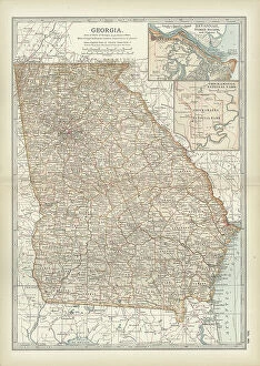
Background imageNavigational Equipment Collection: Map of Georgia, c.1900 (engraving)

Map of Georgia, c.1900 (engraving)
533139 Map of Georgia, c.1900 (engraving); (add.info.: Map of Georgia, United States, with inset maps of Savannah and Chickamauga National Park, circa 1902)

Background imageNavigational Equipment Collection: Map of Yosemite National Park, c.1900 (engraving)

Map of Yosemite National Park, c.1900 (engraving)
532890 Map of Yosemite National Park, c.1900 (engraving); (add.info.: Map of Yosemite National Park, highlighting major parks and other features, circa 1900)

Background imageNavigational Equipment Collection: Map of Maryland and Delaware, c.1900 (engraving)

Map of Maryland and Delaware, c.1900 (engraving)
533120 Map of Maryland and Delaware, c.1900 (engraving); (add.info.: Map of Maryland and Delaware, inset maps of District of Columbia and Baltimore, circa 1902)

Background imageNavigational Equipment Collection: Map of New York State, c.1900 (engraving)

Map of New York State, c.1900 (engraving)
533105 Map of New York State, c.1900 (engraving); (add.info.: Map of north and eastern New York State, United States, circa 1902)

Background imageNavigational Equipment Collection: Map of Connecticut and Rhode Island, c.1900 (engraving)

Map of Connecticut and Rhode Island, c.1900 (engraving)
533101 Map of Connecticut and Rhode Island, c.1900 (engraving); (add.info.: Map of Connecticut and Rhode Island, United States, with an inset of Newport, circa 1902)

Background imageNavigational Equipment Collection: Map of Central Panama, c.1900 (engraving)

Map of Central Panama, c.1900 (engraving)
532816 Map of Central Panama, c.1900 (engraving); (add.info.: Map of central Panama, highlighting the proposed route of the Panama Canal through the isthmus, circa 1900)

Background imageNavigational Equipment Collection: Map of Maine, c.1900 (engraving)

Map of Maine, c.1900 (engraving)
533088 Map of Maine, c.1900 (engraving); (add.info.: Map of Maine, United States, with inset map of Mount Desert Island, circa 1902)

Background imageNavigational Equipment Collection: Map of Liverpool, c.1900 (engraving)

Map of Liverpool, c.1900 (engraving)
532785 Map of Liverpool, c.1900 (engraving); (add.info.: Map of Liverpool, circa 1900, from the 10th edition of Encyclopaedia Britannica.); Encyclopaedia Britannica/UIG

Background imageNavigational Equipment Collection: Map of Honolulu, c.1900 (engraving)

Map of Honolulu, c.1900 (engraving)
532773 Map of Honolulu, c.1900 (engraving); (add.info.: Map of Honolulu, Hawaii, circa 1900, from the 10th edition of Encyclopaedia Britannica.); Encyclopaedia Britannica/UIG

Background imageNavigational Equipment Collection: Map of Hamburg, c.1900 (engraving)

Map of Hamburg, c.1900 (engraving)
532767 Map of Hamburg, c.1900 (engraving); (add.info.: Map of Hamburg, circa 1900, from the 10th edition of Encyclopaedia Britannica.); Encyclopaedia Britannica/UIG

Background imageNavigational Equipment Collection: map of Detroit, c.1900 (engraving)

map of Detroit, c.1900 (engraving)
532755 map of Detroit, c.1900 (engraving); (add.info.: Map of Detroit, Michigan, and the Detroit River, circa 1900, from the 10th edition of Encyclopaedia Britannica.); Encyclopaedia Britannica/UIG

Background imageNavigational Equipment Collection: Map of Dardanelles, c.1900 (engraving)

Map of Dardanelles, c.1900 (engraving)
532751 Map of Dardanelles, c.1900 (engraving); (add.info.: Map of Dardanelles, circa 1900, from the 10th edition of Encyclopaedia Britannica.); Encyclopaedia Britannica/UIG

Background imageNavigational Equipment Collection: Map of Copenhagen, c.1900 (engraving)

Map of Copenhagen, c.1900 (engraving)
532749 Map of Copenhagen, c.1900 (engraving); (add.info.: Map of Copenhagen, Denmark, from the 10th edition of Encyclopaedia Britannica.); Encyclopaedia Britannica/UIG

Background imageNavigational Equipment Collection: Map of Cleveland, c.1900 (engraving)

Map of Cleveland, c.1900 (engraving)
532746 Map of Cleveland, c.1900 (engraving); (add.info.: Map of Cleveland, Ohio, from the 10th edition of Encyclopaedia Britannica.); Encyclopaedia Britannica/UIG

Background imageNavigational Equipment Collection: Map of Chicago, c.1900 (engraving)

Map of Chicago, c.1900 (engraving)
532740 Map of Chicago, c.1900 (engraving); (add.info.: Map of Chicago, Illinois, circa 1900, from the 10th edition of Encyclopaedia Britannica.); Encyclopaedia Britannica/UIG

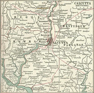
Background imageNavigational Equipment Collection: Map of Calcutta, c.1900 (engraving)

Map of Calcutta, c.1900 (engraving)
532731 Map of Calcutta, c.1900 (engraving); (add.info.: Map of Calcutta (now Kolkata), circa 1900, from the 10th edition of Encyclopaedia Britannica.); Encyclopaedia Britannica/UIG

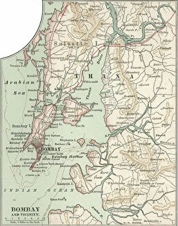
Background imageNavigational Equipment Collection: Map of Bombay (now Mumbai), c.1900 (engraving)

Map of Bombay (now Mumbai), c.1900 (engraving)
532711 Map of Bombay (now Mumbai), c.1900 (engraving); (add.info.: Map of the city of Bombay (now Mumbai) and vicinity, India, circa 1900

Background imageNavigational Equipment Collection: Map of Berlin, c.1900 (engraving)

Map of Berlin, c.1900 (engraving)
532708 Map of Berlin, c.1900 (engraving); (add.info.: Map of the city of Berlin and vicinity, Germany, circa 1900, from the 10th edition of Encyclopaedia Britannica.); Encyclopaedia Britannica/UIG

Background imageNavigational Equipment Collection: Map of Baltimore, c.1900 (engraving)

Map of Baltimore, c.1900 (engraving)
532705 Map of Baltimore, c.1900 (engraving); (add.info.: Map of Baltimore, Maryland, circa 1900, from the 10th edition of Encyclopaedia Britannica.); Encyclopaedia Britannica/UIG

Background imageNavigational Equipment Collection: Map of Athens, c.1900 (engraving)

Map of Athens, c.1900 (engraving)
532702 Map of Athens, c.1900 (engraving); (add.info.: Map showing the historical churches of Athens and Piraeus, circa 1900)

Background imageNavigational Equipment Collection: Map of Corsica, c.1900 (engraving)

Map of Corsica, c.1900 (engraving)
533290 Map of Corsica, c.1900 (engraving); (add.info.: Map of Corsica, France, circa 1902, from the 10th edition of Encyclopaedia Britannica.); Encyclopaedia Britannica/UIG

Background imageNavigational Equipment Collection: Map of Persia with Afghanistan and Baluchistan, c.1900 (engraving)

Map of Persia with Afghanistan and Baluchistan, c.1900 (engraving)
533013 Map of Persia with Afghanistan and Baluchistan, c.1900 (engraving); (add.info.: Map showing the historical boundaries of Persia (now Iran), Afghanistan, and Baluchistan, circa 1902

Background imageNavigational Equipment Collection: Map of Turkey, c.1900 (engraving)

Map of Turkey, c.1900 (engraving)
532998 Map of Turkey, c.1900 (engraving); (add.info.: Map showing historical boundaries of the European portion of Turkey, circa 1902)

Background imageNavigational Equipment Collection: Map of Austria with Vienna, c.1900 (engraving)

Map of Austria with Vienna, c.1900 (engraving)
532980 Map of Austria with Vienna, c.1900 (engraving); (add.info.: Map showing Austria-Hungary, with an inset of Vienna, circa 1902)

Background imageNavigational Equipment Collection: Map of southern Illinois, c.1900 (engraving)

Map of southern Illinois, c.1900 (engraving)
533175 Map of southern Illinois, c.1900 (engraving); (add.info.: Map of the southern part of Illinois, United States, with an inset map of Chicago and Vicinity, circa 1902)

Background imageNavigational Equipment Collection: Map of Indiana, c.1900 (engraving)

Map of Indiana, c.1900 (engraving)
533170 Map of Indiana, c.1900 (engraving); (add.info.: Map of Indiana, United States, circa 1902, from the 10th edition of Encyclopaedia Britannica.); Encyclopaedia Britannica/UIG

Background imageNavigational Equipment Collection: Map of western Texas with Galveston, c.1900 (engraving)

Map of western Texas with Galveston, c.1900 (engraving)
533163 Map of western Texas with Galveston, c.1900 (engraving); (add.info.: Map of the western part of Texas with inset map of Galveston Bay, Galveston, Houston and Vicinity, circa 1902)

Background imageNavigational Equipment Collection: Map of Arkansas, c.1900 (engraving)

Map of Arkansas, c.1900 (engraving)
533157 Map of Arkansas, c.1900 (engraving); (add.info.: Map of Arkansas, United States, circa 1902, from the 10th edition of Encyclopaedia Britannica.); Encyclopaedia Britannica/UIG

Background imageNavigational Equipment Collection: Map of England and Wales, c.1900 (engraving)

Map of England and Wales, c.1900 (engraving)
532927 Map of England and Wales, c.1900 (engraving); (add.info.: Map of England and Wales, circa 1902, from the 10th edition of Encyclopaedia Britannica.); Encyclopaedia Britannica/UIG

Background imageNavigational Equipment Collection: Map of southeast Australia, c.1900 (engraving)

Map of southeast Australia, c.1900 (engraving)
533045 Map of southeast Australia, c.1900 (engraving); (add.info.: Map of southeast Australia with Victoria, New South Wales, and parts of South Australia and Queensland, circa 1902)

Background imageNavigational Equipment Collection: Map of Budapest, c.1900 (engraving)

Map of Budapest, c.1900 (engraving)
532724 Map of Budapest, c.1900 (engraving); (add.info.: Map of the city of Budapest, Hungary from the 10th edition of Encyclopaedia Britannica.); Encyclopaedia Britannica/UIG

Background imageNavigational Equipment Collection: Map of Boston, c.1900 (engraving)

Map of Boston, c.1900 (engraving)
532718 Map of Boston, c.1900 (engraving); (add.info.: Map of the city of Boston, Massachusetts, circa 1900, from the 10th edition of Encyclopaedia Britannica.); Encyclopaedia Britannica/UIG

Background imageNavigational Equipment Collection: Map of Chickamauga National Park, c.1900 (engraving)

Map of Chickamauga National Park, c.1900 (engraving)
533433 Map of Chickamauga National Park, c.1900 (engraving); (add.info.: Map of Chickamauga National Park, Tennessee, circa 1902)

Background imageNavigational Equipment Collection: Map of the western part of Ontario, Canada, c.1900 (engraving)

Map of the western part of Ontario, Canada, c.1900 (engraving)
533408 Map of the western part of Ontario, Canada, c.1900 (engraving); (add.info.: Map of the western part of Ontario, Canada, circa 1902)


All Professionally Made to Order for Quick Shipping

"Unveiling the Past: Navigational Equipment Guides Us Through History" Exploring ancient civilizations: An antique map of the Roman Empire reveals their vast territories and navigational prowess. Tracing Anglo-Saxon roots: Delve into history with an antique map showcasing Britain under the Anglo Saxons, a captivating glimpse into early English heritage. Byzantine marvels in ink: Step back in time as a 9th-century map of the Byzantine Empire unfolds its intricate details, guiding us through this remarkable era. Unraveling Liverpool's maritime legacy: A fascinating 19th-century antique map takes us on a journey through Liverpool and Birkenhead, England, offering insights into their rich nautical history. Ireland's enchanting landscapes mapped: Discover Ireland's allure through an exquisite antique map that showcases its diverse geography and invites exploration. Scottish Isles beckon adventurers: Embark on a virtual voyage to Jura, Mull, Argyll, Islay with a stunning 19th-century antique map that captures Scotland's rugged beauty. Charting New Zealand's discovery: Travel back to 1873 with an extraordinary antique map of New Zealand; witness how explorers navigated these uncharted lands centuries ago. The allure of vintage cartography continues: Immerse yourself in nostalgia with an enchanting vintage map of Magna Graecia - relish its timeless charm and historical significance. Island paradise revealed - Cyprus unveiled. Explore this Mediterranean gem as you trace your fingers across an alluringly detailed vintage map capturing Cyprus' unique essence. Saint Lucia whispers tales from yesteryears: Transport yourself to the Caribbean island paradise as you explore a mesmerizing 19th-century antique map depicting Saint Lucia’s vibrant past. The road less traveled across America awaits.