Home > Arts > Contemporary art > Digital artwork > Street art
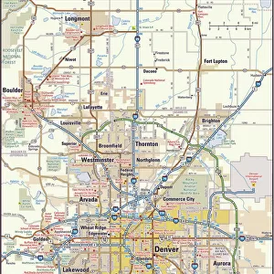
CT Fairfield Darien Vector Road Map

![]()
Wall Art and Photo Gifts from Fine Art Storehouse
CT Fairfield Darien Vector Road Map
CT Fairfield Darien Vector Road Map. All source data is in the public domain. U.S. Census Bureau Census Tiger. Used Layers: areawater, linearwater, roads, rails, cousub, pointlm, uac10
Unleash your creativity and transform your space into a visual masterpiece!
Frank Ramspott
Media ID 20688291
© Frank Ramspott, all rights reserved
City Map Computer Graphic Connecticut County Digital Composite District Fairfield Geographical Border Harbor Long Island Sound Road Map Springdale Text Vector Darien Digitally Generated Image Glenbrook Newfield
FEATURES IN THESE COLLECTIONS
> Animals
> Mammals
> Cats (Wild)
> Tiger
> Animals
> Mammals
> Muridae
> Water Mouse
> Arts
> Contemporary art
> Digital artwork
> Street art
> Arts
> Landscape paintings
> Waterfall and river artworks
> River artworks
> Arts
> Portraits
> Pop art gallery
> Street art portraits
> Arts
> Street art graffiti
> Digital art
> Digital paintings
> Fine Art Storehouse
> Map
> Reference Maps
> Maps and Charts
> Related Images
> Popular Themes
> Lake District
EDITORS COMMENTS
This print showcases the intricate details of the CT Fairfield Darien Vector Road Map. Created by talented artist Frank Ramspott, this digitally generated image is a testament to his exceptional cartography skills and design expertise. The map encompasses various elements such as cities, towns, rivers, lakes, and coastlines with remarkable precision. The vibrant colors used in this vector map bring life to its physical geography and highlight the geographical borders within Connecticut's Fairfield County district. From bustling city streets to serene waterfronts, every aspect of this region is beautifully depicted in this computer graphic masterpiece. With no people present in the image, the focus remains solely on the meticulously crafted road map itself. This visually striking composition serves as an invaluable resource for navigation purposes or simply as a stunning piece of art that captures the essence of Connecticut's landscape. It is worth noting that all source data used in creating this artwork are from public domain sources like U. S. Census Bureau Census Tiger. Layers such as roads, rails, water bodies, and administrative boundaries have been skillfully combined to create a comprehensive representation of Fairfield County's urban and natural features. Whether you're a cartography enthusiast or someone who appreciates fine digital artistry, this print will undoubtedly captivate your imagination with its intricate details and impeccable craftsmanship.
MADE IN THE USA
Safe Shipping with 30 Day Money Back Guarantee
FREE PERSONALISATION*
We are proud to offer a range of customisation features including Personalised Captions, Color Filters and Picture Zoom Tools
SECURE PAYMENTS
We happily accept a wide range of payment options so you can pay for the things you need in the way that is most convenient for you
* Options may vary by product and licensing agreement. Zoomed Pictures can be adjusted in the Cart.