Home > Europe > United Kingdom > England > London > Museums > National Maritime Museum
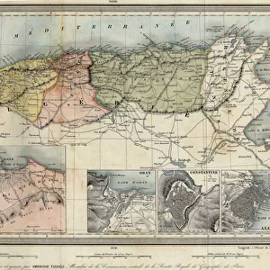
A chart of Delaware Bay and river, containing a full and exact description of the shores, creeks, harbours, soundings, shoals, sands and bearings of the most considerable land marks, from the Capes to Philadelphia, 1776 (engraving)
")
![]()
Wall Art and Photo Gifts from Fine Art Finder
A chart of Delaware Bay and river, containing a full and exact description of the shores, creeks, harbours, soundings, shoals, sands and bearings of the most considerable land marks, from the Capes to Philadelphia, 1776 (engraving)
7339439 A chart of Delaware Bay and river, containing a full and exact description of the shores, creeks, harbours, soundings, shoals, sands and bearings of the most considerable land marks, from the Capes to Philadelphia, 1776 (engraving) by Dury, Andrew & Haydon, W. (fl.1836); 46x70 cm; National Maritime Museum, London, UK; (add.info.: Creator: Andrew Dury; W. Haydon
Taken from the original chart published at Philadelphia by Joshua Fisher.
Scale: circa 1:2, 500, 000 (bar). Scale in English miles. Ungraduated chart. North at 90 degrees. Contents Note: Ships depicted in the channels. Tide table. List of subscribers (pilots and masters of vessels).); © National Maritime Museum, Greenwich, London
Media ID 38519864
© © National Maritime Museum, Greenwich, London / Bridgeman Images
FEATURES IN THESE COLLECTIONS
> Arts
> Artists
> F
> Mark Fisher
> Europe
> France
> Canton
> Landes
> Europe
> United Kingdom
> England
> London
> Boroughs
> Greenwich
> Europe
> United Kingdom
> England
> London
> Museums
> Greenwich Heritage Centre
> Europe
> United Kingdom
> England
> London
> Museums
> National Maritime Museum
> Europe
> United Kingdom
> England
> London
> Towns
> Greenwich
> Europe
> United Kingdom
> Heritage Sites
> Maritime Greenwich
> Europe
> United Kingdom
> Maps
> Fine Art Finder
> Artists
> Unknown Artist
> Maps and Charts
> Early Maps
EDITORS COMMENTS
This detailed engraving from 1776 showcases a chart of Delaware Bay and river, providing a comprehensive description of the shores, creeks, harbours, soundings, shoals, sands, and bearings of the most significant landmarks from the Capes to Philadelphia. Created by Andrew Dury and W. Haydon, this historical piece offers a glimpse into maritime navigation during the 18th century.
The scale of approximately 1:2,500,000 is depicted in English miles on this ungraduated chart with North positioned at 90 degrees. Ships can be seen navigating through the channels while a tide table and list of subscribers add further context to this valuable resource for pilots and masters of vessels.
Published originally in Philadelphia by Joshua Fisher, this engraving captures the essence of cartography in early America. The vibrant colors bring life to the map as it highlights key locations along Delaware Bay and river.
As we admire this piece today at the National Maritime Museum in London, we are transported back in time to an era where exploration and discovery shaped our understanding of geography. This print serves as a reminder of our rich maritime history and the importance of accurate mapping for safe navigation on waterways.
MADE IN THE USA
Safe Shipping with 30 Day Money Back Guarantee
FREE PERSONALISATION*
We are proud to offer a range of customisation features including Personalised Captions, Color Filters and Picture Zoom Tools
SECURE PAYMENTS
We happily accept a wide range of payment options so you can pay for the things you need in the way that is most convenient for you
* Options may vary by product and licensing agreement. Zoomed Pictures can be adjusted in the Cart.