Home > Arts > Artists > D > Fernao Vaz Dourado
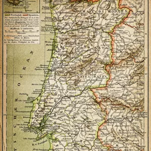
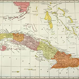
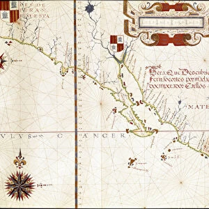
Portulan: Geographic map with the name of the coastline of Cuba, Florida

![]()
Wall Art and Photo Gifts from Fine Art Finder
Portulan: Geographic map with the name of the coastline of Cuba, Florida
AIS5347578 Portulan: Geographic map with the name of the coastline of Cuba, Florida, Central America and North Latin America, Hydrographic Atlas of Fernao VAZ DOURADO (16th century), 1571 (painting) by Dourado, Fernao Vaz (fl.1571); Arquivo Nacional da Torre do Tombo, Lisbon, Portugal; (add.info.: Portulan: Geographic map with the name of the coastline of Cuba, Florida, Central America and North Latin America. Hydrographic Atlas of Fernao VAZ DOURADO (16th century), 1571. PORTUGAL. Lisbon. Torre do Tombo National Archives Institute.); eIberfoto; Portuguese, out of copyright
Media ID 23341320
© Iberfoto / Bridgeman Images
Atlas Book Of Maps Central America Cuba Cuban Cubans Florida Latine America
FEATURES IN THESE COLLECTIONS
> Arts
> Artists
> D
> Fernao Vaz Dourado
> Europe
> Portugal
> Paintings
> Europe
> Portugal
> Related Images
> Fine Art Finder
> Artists
> Fernao Vaz Dourado
> Fine Art Finder
> Artists
> Romanesque
> Maps and Charts
> Related Images
> North America
> Cuba
> Maps
EDITORS COMMENTS
This print showcases a remarkable piece of history, the "Portulan: Geographic map with the name of the coastline of Cuba, Florida". Created by Fernao Vaz Dourado in 1571, this painting is part of the Hydrographic Atlas housed at Arquivo Nacional da Torre do Tombo in Lisbon, Portugal. The intricate details and vibrant colors bring to life the coastlines of Cuba, Florida, Central America, and North Latin America. This map serves as a testament to Dourado's exceptional cartographic skills during the 16th century. As we delve into this masterpiece, we are transported back in time when exploration was at its peak. The names etched along these coastlines evoke a sense of adventure and discovery that characterized this era. From Cuba's rich cultural heritage to Florida's potential as an emerging landmass on the brink of European settlement. With every brushstroke meticulously placed by Dourado's hand, we witness his dedication to accurately depicting these lands for navigational purposes. It is through maps like these that early explorers charted their courses across uncharted territories. This print not only captures a significant historical artifact but also invites us to reflect upon our ever-evolving understanding of geography. It reminds us that even centuries ago, people were driven by curiosity and an insatiable desire for knowledge about our world.
MADE IN THE USA
Safe Shipping with 30 Day Money Back Guarantee
FREE PERSONALISATION*
We are proud to offer a range of customisation features including Personalised Captions, Color Filters and Picture Zoom Tools
SECURE PAYMENTS
We happily accept a wide range of payment options so you can pay for the things you need in the way that is most convenient for you
* Options may vary by product and licensing agreement. Zoomed Pictures can be adjusted in the Cart.