Home > Europe > France > Maps
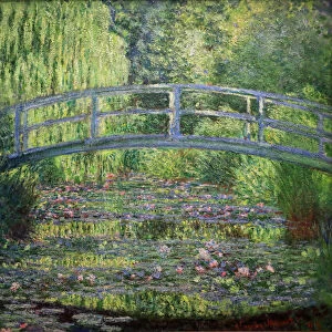
Map showing Napoleon's Empire, France, 1810, from 'France, Mediaeval and Modern A History', pub.1918 (print)
")
![]()
Wall Art and Photo Gifts from Fine Art Finder
Map showing Napoleon's Empire, France, 1810, from 'France, Mediaeval and Modern A History', pub.1918 (print)
3533858 Map showing Napoleon's Empire, France, 1810, from 'France, Mediaeval and Modern A History', pub.1918 (print) by English School, (20th century); (add.info.: Map showing Napoleon's Empire, France, 1810. From France, Mediaeval and Modern A History, published 1918.)
Media ID 38701544
© Bridgeman Images
1810 Bonaparte Bonaparte Family Geographical Napoleon Napoleons
FEATURES IN THESE COLLECTIONS
> Fine Art Finder
> Artists
> English School
> Fine Art Finder
> Artists
> Jean-Marc Nattier
> Maps and Charts
> Early Maps
> Maps and Charts
> Related Images
EDITORS COMMENTS
Step into the grandeur of Napoleon's Empire with this striking print from 'France, Mediaeval and Modern A History', published in 1918. This detailed map showcases the vast territories under Napoleon's control in 1810, spanning across Europe from France to Italy, Germany, Austria, and beyond. The intricate cartography highlights the extent of his imperial ambitions, as he sought to reshape the continent in his image.
As you gaze upon this historic map, imagine the strategic battles fought and won by Napoleon's armies as they conquered much of Europe. Note how his empire stretched from the Pyrenees Mountains to Poland and Russia's borders. The map also reveals the complex network of alliances and rivalries between European powers during this tumultuous period.
This print is a testament to Napoleon's enduring legacy as one of history's most influential leaders. His impact on European politics, culture, and society continues to be felt today. Whether you're a history buff or simply fascinated by geography, this vintage map is a must-have for any collection.
MADE IN THE USA
Safe Shipping with 30 Day Money Back Guarantee
FREE PERSONALISATION*
We are proud to offer a range of customisation features including Personalised Captions, Color Filters and Picture Zoom Tools
SECURE PAYMENTS
We happily accept a wide range of payment options so you can pay for the things you need in the way that is most convenient for you
* Options may vary by product and licensing agreement. Zoomed Pictures can be adjusted in the Cart.