Home > Europe > United Kingdom > Northern Ireland > Aviation
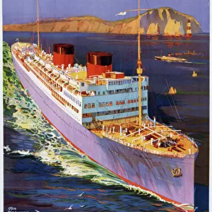
Empire Air Routes: Map of England, South Africa Route (colour litho)
")
![]()
Wall Art and Photo Gifts from Fine Art Finder
Empire Air Routes: Map of England, South Africa Route (colour litho)
8659267 Empire Air Routes: Map of England, South Africa Route (colour litho) by English School, (20th century); Private Collection; (add.info.: Map of England, South Africa Route. Illustration for one of a set of cigarette cards on the subject of Empire Air Routes, issued by Lambert & Butler in 1936.); © Look and Learn
Media ID 38291718
© © Look and Learn / Bridgeman Images
1930 1939 Years 30 30s 1930 1939 Years 30s 19301939 1933 34 Years 1930 Years 30 Years Thirty
FEATURES IN THESE COLLECTIONS
> Africa
> Related Images
> Africa
> South Africa
> Maps
> Africa
> South Africa
> Related Images
> Arts
> Artists
> I
> Irish School Irish School
> Europe
> Republic of Ireland
> Maps
> Europe
> United Kingdom
> England
> Aviation
> Europe
> United Kingdom
> England
> Maps
> Europe
> United Kingdom
> Maps
> Europe
> United Kingdom
> Northern Ireland
> Aviation
> Europe
> United Kingdom
> Northern Ireland
> Maps
> Fine Art Finder
> Artists
> English School
EDITORS COMMENTS
This vibrant and detailed map print titled "Empire Air Routes: Map of England, South Africa Route" takes us back to the early 20th century when aviation was still in its infancy. Created by an English School artist, this colour lithograph showcases the intricate network of air routes connecting England to South Africa.
Issued as part of a set of cigarette cards by Lambert & Butler in 1936, this map highlights the advancements in flight technology during that time. The bold colors and precise details on the map capture the essence of exploration and adventure that came with air travel in the 1930s.
As we gaze upon this historical artwork, we are transported to a time when flying was a luxury reserved for only a few brave souls. The routes depicted on this map symbolize not just physical connections between distant lands but also represent the spirit of innovation and progress that defined the early days of aviation.
With Europe as its starting point, this map serves as a reminder of how far we have come in terms of global connectivity through air travel. It is a testament to human ingenuity and determination to conquer new frontiers, both literally and figuratively.
MADE IN THE USA
Safe Shipping with 30 Day Money Back Guarantee
FREE PERSONALISATION*
We are proud to offer a range of customisation features including Personalised Captions, Color Filters and Picture Zoom Tools
SECURE PAYMENTS
We happily accept a wide range of payment options so you can pay for the things you need in the way that is most convenient for you
* Options may vary by product and licensing agreement. Zoomed Pictures can be adjusted in the Cart.