Home > Europe > United Kingdom > England > London > Sights > New River
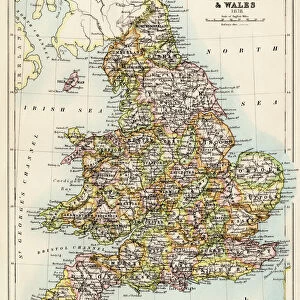
Map of the inland navigation of England and Wales by the canals and principal rivers, 1809. Copperplate engraving by Mutlow from John Mason Good's Pantologia, a New Encyclopedia, G. Kearsley, London, 1813

![]()
Wall Art and Photo Gifts from Fine Art Finder
Map of the inland navigation of England and Wales by the canals and principal rivers, 1809. Copperplate engraving by Mutlow from John Mason Good's Pantologia, a New Encyclopedia, G. Kearsley, London, 1813
FLO4974709 Map of the inland navigation of England and Wales by the canals and principal rivers, 1809. Copperplate engraving by Mutlow from John Mason Good's Pantologia, a New Encyclopedia, G. Kearsley, London, 1813.; (add.info.: Map of the inland navigation of England and Wales by the canals and principal rivers, 1809. Copperplate engraving by Mutlow from John Mason Good's Pantologia, a New Encyclopedia, G. Kearsley, London, 1813.); © Florilegius
Media ID 38354440
© © Florilegius / Bridgeman Images
Angleterre Canal Canals Carte Geographique Chart Fleuve Freight Geographe Industrial Revolution John Mason Good Kearsley New Encyclopedia Pantologia Waterways Allemagne Geographer Geographical Map Grande Bretagne Mutlow
FEATURES IN THESE COLLECTIONS
> Europe
> United Kingdom
> England
> London
> Sights
> New River
> Europe
> United Kingdom
> England
> Maps
> Europe
> United Kingdom
> England
> Rivers
> Europe
> United Kingdom
> Maps
> Europe
> United Kingdom
> Wales
> Maps
> Europe
> United Kingdom
> Wales
> Posters
> Europe
> United Kingdom
> Wales
> Rivers
> Fine Art Finder
> Artists
> Aime Jules Dalou
EDITORS COMMENTS
This stunning copperplate engraving from 1809 depicts a detailed map of the inland navigation of England and Wales, showcasing the intricate network of canals and principal rivers that were vital for transportation during the Industrial Revolution. Created by Mutlow and featured in John Mason Good's Pantologia, this historical piece offers a glimpse into the past when these waterways played a crucial role in facilitating trade and commerce across the region.
The meticulous craftsmanship of this engraving captures not only the geographical layout but also highlights the importance of transport infrastructure in shaping economic development. The intricate details on this map provide valuable insights into how goods were transported through these water routes, connecting different regions and fostering growth in industries such as freight and manufacturing.
As you admire this exquisite print, you can't help but marvel at the ingenuity of those who designed and built these canals centuries ago. Each line and curve on this map tells a story of innovation and progress, reflecting a time when England and Wales were at the forefront of industrial advancements. This piece is not just a visual representation but a testament to human endeavor and perseverance in overcoming geographical challenges for societal advancement.
MADE IN THE USA
Safe Shipping with 30 Day Money Back Guarantee
FREE PERSONALISATION*
We are proud to offer a range of customisation features including Personalised Captions, Color Filters and Picture Zoom Tools
SECURE PAYMENTS
We happily accept a wide range of payment options so you can pay for the things you need in the way that is most convenient for you
* Options may vary by product and licensing agreement. Zoomed Pictures can be adjusted in the Cart.