Home > Animals > Mammals > Didelphidae > Formosa
1876 Imray Blue-back Nautical Chart Or Map Of Taiwan

![]()
Wall Art and Photo Gifts from Universal Images Group (UIG)
1876 Imray Blue-back Nautical Chart Or Map Of Taiwan
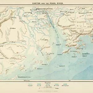
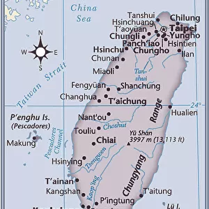
1876, Imray Blue-back Nautical Chart or Map of Taiwan, Formosa, China
Universal Images Group (UIG) manages distribution for many leading specialist agencies worldwide
Media ID 38549930
© Artokoloro Quint Lox Limited
1876 China Antique Map Formosa Latitude Longitude Mappa Mundi Old Antique Plan Old Antique View Ols Antique Map Rare Old Maps Topo
FEATURES IN THESE COLLECTIONS
> Animals
> Mammals
> Didelphidae
> Formosa
> Asia
> China
> Related Images
> Asia
> Taiwan
> Related Images
> Europe
> France
> Canton
> Landes
> Historic
> Space exploration
> Maps and Charts
> Early Maps
> Maps and Charts
> Related Images
> Universal Images Group (UIG)
> History
> Historical Maps
EDITORS COMMENTS
Step back in time to the late 19th century with this stunning 1876 Imray Blue-back Nautical Chart of Taiwan, Formosa, China. This vintage map is a treasure trove of geographical knowledge and historical significance, offering a glimpse into the world as it was over a century ago.
The chart is meticulously hand-colored and features intricate details of the island's coastline, mountains, rivers, and cities. The Imray Blue-back series was renowned for its accuracy and attention to detail, making it an essential tool for navigators and explorers of the time.
This beautiful print not only showcases the cartography skills of its creators but also provides a fascinating insight into Taiwan's history during the Qing dynasty. It highlights the country's strategic importance as a trading hub between China and Japan.
Today, this antique map serves as a decorative piece that adds a touch of elegance to any room. Its unique blend of artistry and functionality makes it an excellent conversation starter for anyone interested in history, geography, or nautical exploration. Whether you're an avid collector or simply someone who appreciates rare treasures from yesteryear, this 1876 Imray Blue-back Nautical Chart is sure to captivate your imagination.
MADE IN THE USA
Safe Shipping with 30 Day Money Back Guarantee
FREE PERSONALISATION*
We are proud to offer a range of customisation features including Personalised Captions, Color Filters and Picture Zoom Tools
SECURE PAYMENTS
We happily accept a wide range of payment options so you can pay for the things you need in the way that is most convenient for you
* Options may vary by product and licensing agreement. Zoomed Pictures can be adjusted in the Cart.