Home > Europe > France > Canton > Landes
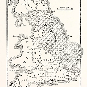
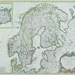
1840 Lizars Map Of Scandinavia Norway Sweden

![]()
Wall Art and Photo Gifts from Universal Images Group (UIG)
1840 Lizars Map Of Scandinavia Norway Sweden
1840, Lizars Map of Scandinavia, Norway, Sweden, Finland, Denmark, Iceland
Universal Images Group (UIG) manages distribution for many leading specialist agencies worldwide
Media ID 38548609
© Artokoloro Quint Lox Limited
1840 Denmark Finland Iceland Norway Sweden Antique Map Latitude Longitude Mappa Mundi Old Antique Plan Old Antique View Ols Antique Map Rare Old Maps Topo
FEATURES IN THESE COLLECTIONS
> Europe
> Denmark
> Related Images
> Europe
> Finland
> Related Images
> Europe
> France
> Canton
> Landes
> Europe
> Iceland
> Related Images
> Europe
> Norway
> Related Images
> Universal Images Group (UIG)
> History
> Historical Maps
EDITORS COMMENTS
Step back in time to the mid-19th century with this stunning print of Lizars' 1840 Map of Scandinavia, Norway, Sweden, Finland, Denmark, and Iceland. This beautifully illustrated map is a testament to the cartographic skills of Scottish artist William Home Lizars, who was renowned for his meticulous attention to detail and artistic flair.
The map showcases the geographical boundaries and topographical features of these six Scandinavian countries with remarkable accuracy. From the rugged mountains of Norway to the vast expanses of Swedish forests, every region is meticulously depicted in intricate detail. The map also highlights major cities, rivers, lakes, and coastlines, providing a comprehensive overview of this fascinating region.
This vintage map is not only a valuable historical artifact but also a work of art that evokes a sense of adventure and exploration. Imagine being part of an era when maps were hand-drawn masterpieces that told stories about far-off lands and unknown territories. This print would make a unique addition to any room's décor or office space, inspiring conversations about history, geography, and travel.
Take yourself on a journey through time with this print from Universal Images Group (UIG). Let your imagination run wild as you explore the wonders hidden within its borders.
MADE IN THE USA
Safe Shipping with 30 Day Money Back Guarantee
FREE PERSONALISATION*
We are proud to offer a range of customisation features including Personalised Captions, Color Filters and Picture Zoom Tools
SECURE PAYMENTS
We happily accept a wide range of payment options so you can pay for the things you need in the way that is most convenient for you
* Options may vary by product and licensing agreement. Zoomed Pictures can be adjusted in the Cart.