Home > Europe > France > Canton > Landes
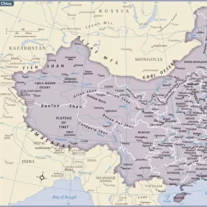
1799 Clement Cruttwell Map Of China Korea And Taiwan

![]()
Wall Art and Photo Gifts from Universal Images Group (UIG)
1799 Clement Cruttwell Map Of China Korea And Taiwan
1799, Clement Cruttwell Map of China, Korea, and Taiwan
Universal Images Group (UIG) manages distribution for many leading specialist agencies worldwide
Media ID 38548303
© Artokoloro Quint Lox Limited
1799 Korea Antique Map Latitude Longitude Mappa Mundi Old Antique Plan Old Antique View Ols Antique Map Rare Old Maps Topo
FEATURES IN THESE COLLECTIONS
> Asia
> China
> Related Images
> Asia
> Taiwan
> Related Images
> Europe
> France
> Canton
> Landes
> Historic
> Space exploration
> Maps and Charts
> Early Maps
> Maps and Charts
> Related Images
> Maps and Charts
> World
> Universal Images Group (UIG)
> History
> Historical Maps
EDITORS COMMENTS
Step back in time and explore the ancient world with this stunning 1799 Clement Cruttwell Map of China, Korea, and Taiwan. This vintage map is a masterpiece of cartography, showcasing the geographical knowledge of the late 18th century. The intricate details and illustrations on this print are a testament to the skill and craftsmanship of its creator.
The map depicts the region's topography, including mountains, rivers, and coastal lines, as well as cities and towns. It also features latitude and longitude grids, giving insight into the understanding of spatial relationships during that era. The illustration style is characteristic of traditional Chinese art, blending ornate designs with practical geographic information.
This rare antique map provides a fascinating glimpse into history's journey towards modern cartography. It would make a beautiful addition to any room or office space, serving as a conversation piece for anyone interested in geography, history, or vintage maps. Whether you're an avid traveler or simply appreciate the beauty of old-world design, this print is sure to captivate your imagination.
MADE IN THE USA
Safe Shipping with 30 Day Money Back Guarantee
FREE PERSONALISATION*
We are proud to offer a range of customisation features including Personalised Captions, Color Filters and Picture Zoom Tools
SECURE PAYMENTS
We happily accept a wide range of payment options so you can pay for the things you need in the way that is most convenient for you
* Options may vary by product and licensing agreement. Zoomed Pictures can be adjusted in the Cart.