Fraud Blocker Skip to main content

Sheffield Collection (#8)

"Sheffield: A Tapestry of History and Culture" Step into the time capsule and journey back to c

Background imageSheffield Collection: Alderman William Henry Brittain, Lord Mayor of Sheffield, Yorkshire, 1884

Alderman William Henry Brittain, Lord Mayor of Sheffield, Yorkshire, 1884
From an original at Sheffield Libraries: arc02922

Background imageSheffield Collection: Thursday Afternoon Working Party, possibly St. Cuthberts, Sheffield, Yorkshire, c. 1920

Thursday Afternoon Working Party, possibly St. Cuthberts, Sheffield, Yorkshire, c. 1920
From an original at Sheffield Libraries: p00044

Background imageSheffield Collection: Mothers Union, St. Cuthberts C. of E. Church, Sheffield, Yorkshire, 1926

Mothers Union, St. Cuthberts C. of E. Church, Sheffield, Yorkshire, 1926
From an original at Sheffield Libraries: p00065

Background imageSheffield Collection: Political cartoon depicting Lord Rosebery in Sheffield, 19th cent

Political cartoon depicting Lord Rosebery in Sheffield, 19th cent
Archibald Philip Primrose, 5th Earl of Rosebery, was a Liberal politician, serving as Prime Minister in 1894-1895. From an original at Sheffield Libraries: s44975

Background imageSheffield Collection: Postcard advertisement for Empire, ladies outfitters, No. 9 Castle Street, sheffield, Yorkshire

Postcard advertisement for Empire, ladies outfitters, No. 9 Castle Street, sheffield, Yorkshire, c. 1900
From an original at Sheffield Libraries: s44974

Background imageSheffield Collection: Workers at the Vanadium Steel Company Ltd, Union Lane, Sheffield, Yorkshire, late 19th cent

Workers at the Vanadium Steel Company Ltd, Union Lane, Sheffield, Yorkshire, late 19th cent
From an original at Sheffield Local Studies Library: s09223

Background imageSheffield Collection: Falmouth Road (Abbeydale House on right)

Falmouth Road (Abbeydale House on right)
From an original at Sheffield Libraries: p00020

Background imageSheffield Collection: Map of Joseph Machens Farm at Wadsley Bridge, Sheffield, 1790

Map of Joseph Machens Farm at Wadsley Bridge, Sheffield, 1790
Full title: A map of Joseph Machens Farm at Wadsley Bridge held of the Duke of Norfolk with other intermediate lands Scale 4 chains : 1 inch [20 inches : 1 mile]. Surveyor: William Fairbank II

Background imageSheffield Collection: Holy Trinity, Wicker Sheffield, centenary 1848-1948

Holy Trinity, Wicker Sheffield, centenary 1848-1948
From an original at Sheffield Libraries: y13241

Background imageSheffield Collection: Sheffield Wednesday v Glasgow - Ibrox Park, 1913

Sheffield Wednesday v Glasgow - Ibrox Park, 1913
From an original in Sheffield Libraries: u01001

Background imageSheffield Collection: Sheffield Wednesday F. C. - Season 1922-1923

Sheffield Wednesday F. C. - Season 1922-1923
Back Row: Gray, Williams, Davison, Prior, Binks, Brelsford, Jackson (Trainer). Front Row: Lowdell, Kean, G. Wilson, Petrie, Lofthouse. From an original in Sheffield Libraries: u01000

Background imageSheffield Collection: Sheffield Wednesday F. C. team photograph, 1920

Sheffield Wednesday F. C. team photograph, 1920
From an original in Sheffield Libraries: u00985

Background imageSheffield Collection: Sheffield Wednesday Football Club 1925 / 6

Sheffield Wednesday Football Club 1925 / 6
Back Row: F Kean, A Lowdell, W Felton, J Brown, F Froggatt (captain), E Blenkinsop, W Marsden. Front Row: Rus Williams, M Barrass, J Trotter, H Hill, A Prince

Background imageSheffield Collection: Tom E. Cawley, footballer who played for Sheffield Wednesday (1882-1891) and Sheffield United

Tom E. Cawley, footballer who played for Sheffield Wednesday (1882-1891) and Sheffield United
From an original in Sheffield Libraries: u01193

Background imageSheffield Collection: Sheffield United Football Team, 1893

Sheffield United Football Team, 1893
Back Row: F.H. Davies; H.H.Stones; J.Scott; J.W.Lilley Middle Row: D. Patterson; R.Howell; R.Cain; C.H. Howlett; W. Hendry; E.H. lilley; W. Nisbett; J. Hounsley Seated: Mr. C. Stokes; A Wallace; S

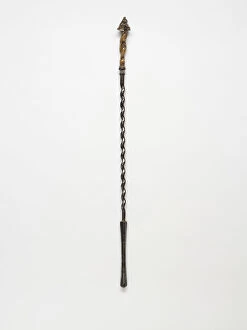
Background imageSheffield Collection: Poker, detail

Poker, detail
Cast polished steel fire poker with a twisted brass handle and a floral finial, part of a set of fire tools including tongs and a shovel

Background imageSheffield Collection: Fire shovel, reverse

Fire shovel, reverse
Cast polished steel fire shovel with a decorative brass handle, a floral finial and a bell-shaped blade with a pierced flower motif, part of a set of fire tools including tongs and a poker

Background imageSheffield Collection: Poker

Poker
Cast polished steel fire poker with a twisted brass handle and a floral finial, part of a set of fire tools including tongs and a shovel

Background imageSheffield Collection: Wightman family and friends group of 14 individuals in unknown garden setting, c. 1910

Wightman family and friends group of 14 individuals in unknown garden setting, c. 1910
The identifiable figures are thought to be as follows: Back row (stood left to right): 1. Benjamin Arthur Wightman (1873 - 1937), eldest son of Arthur Wightman (1842 - 1924); 2

Background imageSheffield Collection: List of armour in Sheffield castle, 1586

List of armour in Sheffield castle, 1586
Full title " A note takenn of all my L. Armorre by Mr Whyat wch came from Yor Lp from Aurtoun Lang-feld when Yor Lp Lyed their the xvi th of November 1586 as followethe." Transcript

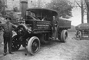
Background imageSheffield Collection: Walter Spencer and Co. Ltd. steam lorry at Rivelin Glen Quarry, Sheffield, Yorkshire, 1920s

Walter Spencer and Co. Ltd. steam lorry at Rivelin Glen Quarry, Sheffield, Yorkshire, 1920s
Original At Sheffield Libraries: s44894

Background imageSheffield Collection: Wightman family Victorian picnic, Yorkshire, 1893

Wightman family Victorian picnic, Yorkshire, 1893
Arthur Wightman (1842 - 1924) is the figure on the far left of the photograph, partially obscured by a young lady in front of him, who is thought to be Annie Maud Wightman (1854 - 1940)

Background imageSheffield Collection: View of Howard Street and Town Hall extension (Egg Box), Sheffield, Yorkshire, 1980

View of Howard Street and Town Hall extension (Egg Box), Sheffield, Yorkshire, 1980
From an original at Sheffield Libraries: s44819

Background imageSheffield Collection: Small tortoishell butterfly (Aglais urticae) on a stained glass window of church

Small tortoishell butterfly (Aglais urticae) on a stained glass window of church on a sunny day Sheffield, England, UK, January

Background imageSheffield Collection: Sheffield Schools Empire Day Pageant, Bramall Lane, 1907

Sheffield Schools Empire Day Pageant, Bramall Lane, 1907
From an original at Sheffield City Libraries: y13082

Background imageSheffield Collection: Colvers Yard (built 1828), Upwell Street, Grimesthorpe, Wincobank, Sheffield

Colvers Yard (built 1828), Upwell Street, Grimesthorpe, Wincobank, Sheffield
From an original at Sheffield Libraries: s11441

Background imageSheffield Collection: Arundel Gate looking towards Castle Square showing (right) the Top Rank Suite and (centre left)

Arundel Gate looking towards Castle Square showing (right) the Top Rank Suite and (centre left)
From an original at Sheffield Libraries: s44263

Background imageSheffield Collection: Side by Side

Side by Side
Mark Tierney

Background imageSheffield Collection: Bacon's large scale plan of Sheffield, c.1890s

Bacon's large scale plan of Sheffield, c.1890s
Published by G W Bacon & Co Ltd. c. 1890s. Scale [7.4 inches : 1 mile]. Shows Borough wards. Dimensions of original: 70 x 55 cm. Original at Sheffield Libraries: y15494

Background imageSheffield Collection: 1 Maps 3 05

1 Maps 3 05
Emiliano Deificus

Background imageSheffield Collection: Sheffield Arena - Sheffield Steelers Ice Hockey

Sheffield Arena - Sheffield Steelers Ice Hockey
Sheffield Arena, known for sponsorship purposes as Utilita Arena Sheffield, is a multi-purpose arena located in Sheffield, England

Background imageSheffield Collection: Ordnance Survey Map, Sheffield, Cornish Street area, Netherthorpe, Sheffield

Ordnance Survey Map, Sheffield, Cornish Street area, Netherthorpe, Sheffield, 1889 (Yorkshire sheet 294. 7. 5)
This map features: Top left: Bedford Street, Burys and Co. Ltd. steel manufacturers, Regent Works, Penistone Road and Philadelphia Steel Works, Penistone Road / Bedford Street, Penistone Road

Background imageSheffield Collection: Ordnance Survey Map, Sheffield, Blake Street area, Netherthorpe, Sheffield

Ordnance Survey Map, Sheffield, Blake Street area, Netherthorpe, Sheffield, 1889 (Yorkshire sheet No. 294. 7. 3)
This map features: Top left: Daniel Hill Street, Elton Street, Harworth Street, Harworth Road, Walkley Street, Duncombe Street, Fulton Road, Blake Street Hotel Public House [Blake Hotel]

Background imageSheffield Collection: Ordnance Survey Map, Sheffield, Cromwell Street area, Walkley, Sheffield

Ordnance Survey Map, Sheffield, Cromwell Street area, Walkley, Sheffield, 1889 (Yorkshire sheet No. 294. 7. 2)
This map features: Top left: Fir Street, Hadfield Street, Fir Spring House, Cundy Street, South Road, St. Marys Church [Walkley], Grove Terrace, Eveline Terrace, Olivet Mount, Lorne House, The Grove

Background imageSheffield Collection: Ordnance Survey Map, Bessemer Road area, Attercliffe, Sheffield, 1889 (Yorkshire sheet No. 294. 4)

Ordnance Survey Map, Bessemer Road area, Attercliffe, Sheffield, 1889 (Yorkshire sheet No. 294. 4. 25)
This map features: Top left: River Don, Crown Steel and Wire Works, Bessemer Road [Arthur Lee and Sons Ltd. steel and wire manufacturers], Princess Street, Midland Railway, Savile Street East

Background imageSheffield Collection: Plan of Thomas Rawson and Co. Pond Street Brewery, Sheffield, Yorkshire, 1832

Plan of Thomas Rawson and Co. Pond Street Brewery, Sheffield, Yorkshire, 1832
Marked: Pond Street, Arundel Street, vacant ground or hop yard, houses, malt houses, joiners shops, stables, shed, coopers shops, scalding room, malt warehouse with vat houses under, drying kilns

Background imageSheffield Collection: Ordnance Survey Map, Gower Street area, Burngreave, Sheffield, 1889 (Yorkshire sheet No. 294. 4. 23)

Ordnance Survey Map, Gower Street area, Burngreave, Sheffield, 1889 (Yorkshire sheet No. 294. 4. 23)
This map features: Top left: Buckenham Road, Ditchingham Road, Catherine Road, Granville Street, Grimesthorpe Road, Bressinghham Road, Ellesmere Road, Clun Road, Petre Street, Buckenham Street

Background imageSheffield Collection: Ordnance Survey Map, Somerset Street area, Burngreave, Sheffield, 1889 (Yorkshire sheet no. 294)

Ordnance Survey Map, Somerset Street area, Burngreave, Sheffield, 1889 (Yorkshire sheet no. 294. 4. 22)
This map features: Top left: Rock Street, Nottingham Street, Brackley Street, Somerset Road, Catherine Street, Somerset Street, Leicester Villas, Fox Street, Cranworth Road, Brotherton Street

Background imageSheffield Collection: Ordnance Survey Map, Lyons Street / Carlisle Street area, Sheffield, 1889 (Yorkshire sheet no)

Ordnance Survey Map, Lyons Street / Carlisle Street area, Sheffield, 1889 (Yorkshire sheet no. 294. 4. 19)
This map features: Top left: Jamaica Street, Kingston Street, Petre Street, Edgar Street, Thorndon Road (marked in pencil), Earsham Street, Lyons Street, Carwood Lane Brick and Stone Works, Kiln

Background imageSheffield Collection: Ordnance Survey Map, Ellesmere Road / Lyons Road area of Sheffield

Ordnance Survey Map, Ellesmere Road / Lyons Road area of Sheffield, 1889 (Yorkshire sheet number 294. 4. 18)
This map features: Top left: Earldom Street, Grimesthorpe Road, Lyons Road, The Hills, Malton Street, Burngreave Cemetery, Hooton Street, Lucas Street, Normanton Street

Background imageSheffield Collection: Ordnance Survey Map, Burngreave area of Sheffield, 1889 (Yorkshire sheet number 294. 4. 17)

Ordnance Survey Map, Burngreave area of Sheffield, 1889 (Yorkshire sheet number 294. 4. 17)
This map features Top left: Minna Road, Burngreave Road, Melrose Road, Fox Street, Pilgrim Street, Melrose Villas, [Burngreave Road Wesleyan Chapel] Methodist Chapel

Background imageSheffield Collection: Ordnance Survey Map, Carwood Road / Petre Street area of Sheffield

Ordnance Survey Map, Carwood Road / Petre Street area of Sheffield, 1889 (Yorkshire sheet number 294. 4. 14)
his map features: Top left: Meadow Head [?house], Carwood Lane. Added in pencil Carwood Terrace. Top right: Recreation Ground

Background imageSheffield Collection: Junction - Angel Street and High Street, Sheffield, South Yorkshire, England

Junction - Angel Street and High Street, Sheffield, South Yorkshire, England. Date: 1964

Background imageSheffield Collection: Champion (Scissors) Ltd, Sheffield, Yorkshire

Champion (Scissors) Ltd, Sheffield, Yorkshire
Champion (Scissors) Ltd, Champion Works, Petre Street, Sheffield, Yorkshire -- Rebuilding British Kitchens. Offer of Kumfi-Kut kitchen scissors when limited supplies permit, in a postwar letter

Background imageSheffield Collection: The Old Wicker Railway Station, Sheffield, South Yorkshire

The Old Wicker Railway Station, Sheffield, South Yorkshire
The Old Wicker Railway Station building in Sheffield, South Yorkshire, which opened in 1838. In 1870 it was closed to passengers, being used for freight and renamed Wicker Goods. Date: circa 1840s

Background imageSheffield Collection: Plan of part of Broom Hall Lane, Sheffield, 1830

Plan of part of Broom Hall Lane, Sheffield, 1830
Signed by T.B. Holy and A. Lawson. Scale 1 inch : 10 yards. Dimensions of approx. 98 x 39 cm. Shows Broom Lodge, Hanover Road, Clarence Street, Headford Street

Background imageSheffield Collection: Plan of part of the west side of the township of Sheffield, 1829

Plan of part of the west side of the township of Sheffield, 1829
Full title: Plan of part of the west side of the township of Sheffield shewing the parts of Nether Hallam and Ecclesall Bierlow intermixed therewith and adjoining upon it

Background imageSheffield Collection: Plan of part of the townships of Sheffield and Ecclesall Bierlow

Plan of part of the townships of Sheffield and Ecclesall Bierlow, shewing the ancient boundary line, 1835
By J. Fairbank and Son. Also signed by W. Smith, Joshua Denton, Thomas Turner and Joseph Senior, Overseers of the Poor of Sheffield and Josiah Davy, John Smith, Samuel Mitchell and John Ward


All Professionally Made to Order for Quick Shipping

"Sheffield: A Tapestry of History and Culture" Step into the time capsule and journey back to c. 1970, where The Hole in The Road stood as a quirky landmark in Sheffield, Yorkshire. This peculiar underpass captured the essence of a city constantly evolving. Fast forward to Hillsborough Art - Sheffield Wednesday, an emblematic representation of the city's passion for football. The vibrant colors on canvas depict the unwavering spirit that unites its people. Delve even deeper into history with William Fairbank's meticulous map from 1771, revealing a correct plan of the town of Sheffield. This intricate cartography showcases how this industrial hub was shaped over centuries. William Ibbitt's masterpiece from 1855 offers us a breathtaking view from Park Hill. From this vantage point, one can witness both progress and tradition intertwining harmoniously. Bramall Lane Art - Sheffield United takes us on another sporting journey through artistry. Celebrating fierce rivalries and moments etched in time, it encapsulates the pride that courses through every fan's veins. Traveling further ahead to c. 1870-1905, we encounter an intriguing Plan which illustrates urban expansion during this period—a testament to its growing prominence within Yorkshire and England at large. Uncover more secrets as you explore Postcode Sector Map sheet 18 Humberside and North East Midlands—an invaluable tool guiding residents across diverse neighborhoods within this sprawling metropolis. Transport yourself back to 1822 when Sheffield was bustling with life—its streets alive with commerce and innovation shaping its destiny as an industrial powerhouse. Witness Tinsley cooling towers towering above the skyline—a symbol not only of energy production but also resilience amidst changing times—a reminder that progress comes hand-in-hand with adaptation. Navigate your way through Postcode District Map sheet 4 Northern England—the key unlocking access to hidden gems nestled within each district—revealing the vibrant tapestry of communities that make up Sheffield.