Fraud Blocker Skip to main content

Geography Collection (#7)

"Exploring the Rich Tapestry of Geography: From Ancient Maps to Modern Wonders" The Al-Idrisi's world map from 1154 takes us back in time

Background imageGeography Collection: Close-up of white water in the Dunns River Falls

Close-up of white water in the Dunns River Falls, Ocho Rico, Jamaica, Caribbean

Background imageGeography Collection: Lake Moraine, Valley of the Ten Peaks, Banff National Park, Alberta, Canada

Lake Moraine, Valley of the Ten Peaks, Banff National Park, Alberta, Canada

Background imageGeography Collection: Dawn over Bukit or Mt. Danum and the virgin dipterocarp rainforest canopy

Dawn over Bukit or Mt. Danum and the virgin dipterocarp rainforest canopy
Dawn over Bukit or Mt.Danum and the virgin dipterocarp rainforest canopy, Danum Valley, Sabah, Borneo, Asia

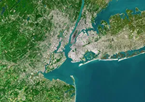
Background imageGeography Collection: New York City, satellite image

New York City, satellite image
New York City, USA, satellite image. North is attop. Urban areas are white, vegetation is greenand water is blue. The island of Manhattan is atupper centre on the east coast of the HudsonRiver

Background imageGeography Collection: EyeUbiquitous_20120989

EyeUbiquitous_20120989
Ireland, County Antrim, Causeway Coast, Carrick a Rede Rope Bridge

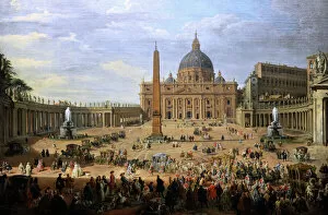
Background imageGeography Collection: The output of the Duke of Choiseul (1719-1785) of St. Peter

The output of the Duke of Choiseul (1719-1785) of St. Peter
Giovanni Paolo Panini (1691-1765). Italian painter. The output of the Duke of Choiseul (1719-1785) of St. Peters Square in Rome, 1754. Gemaldegalerie. Berlin. Germany

Background imageGeography Collection: Chaging of the guard. Athens. Greece

Chaging of the guard. Athens. Greece
Changing of the guar. The Tomb of the Unknown Soldier. Athens. Attica. Greece

Background imageGeography Collection: 1706, De La Feuille Map of Europe, topography, cartography, geography, land, illustration

1706, De La Feuille Map of Europe, topography, cartography, geography, land, illustration
1706, De La Feuille Map of Europe

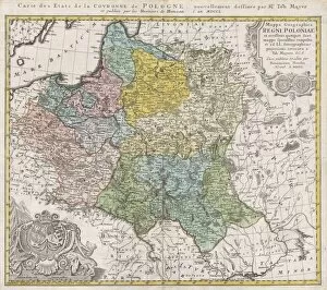
Background imageGeography Collection: 1750, Homann Heirs Map of Poland, topography, cartography, geography, land, illustration

1750, Homann Heirs Map of Poland, topography, cartography, geography, land, illustration
1750, Homann Heirs Map of Poland

Background imageGeography Collection: 1890, Bacon Travelers Pocket Map of London, England, topography, cartography

1890, Bacon Travelers Pocket Map of London, England, topography, cartography
1890, Bacon Travelers Pocket Map of London, England

Background imageGeography Collection: 1865, Spruner Map of Israel, Canaan, or Palestine in Ancient Times, topography, cartography

1865, Spruner Map of Israel, Canaan, or Palestine in Ancient Times, topography, cartography
1865, Spruner Map of Israel, Canaan, or Palestine in Ancient Times

Background imageGeography Collection: 1570, Ortelius Map of Asia, first edition, Abraham Ortelius, also Orthellius, 1527 - 1598

1570, Ortelius Map of Asia, first edition, Abraham Ortelius, also Orthellius, 1527 - 1598, Flemish, Netherlandish cartographer and geographer

Background imageGeography Collection: Illustration of map highlighting Indus Valley region and ancient tablet showing water buffalo

Illustration of map highlighting Indus Valley region and ancient tablet showing water buffalo

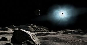
Background imageGeography Collection: The bright star Rigel eclipsed by a moon of a hypothetical planet

The bright star Rigel eclipsed by a moon of a hypothetical planet
Rigel is one of the two brightest stars in the constellation Orion. It is a blue-white giant star. We see it here eclipsed by a moon of a hypothetical planet

Background imageGeography Collection: View of Burns Cliff on Mars

View of Burns Cliff on Mars
The Mars Exploration Rover Opportunity captured this view of Burns Cliff after driving right to the base of this southeastern portion of the inner wall of Endurance Crater

Background imageGeography Collection: Starry night sky above Alamut castle, Qazvin Province, Iran

Starry night sky above Alamut castle, Qazvin Province, Iran

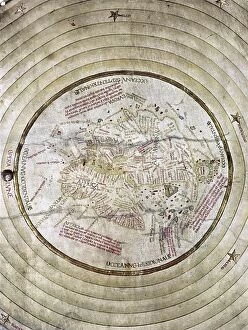
Background imageGeography Collection: WORLD MAP, c1490. Map of the world incorporating the discoveries of Bartholomeu Diaz in 1488

WORLD MAP, c1490. Map of the world incorporating the discoveries of Bartholomeu Diaz in 1488, but not those of Christopher Columbus

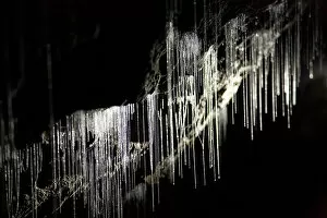
Background imageGeography Collection: Glow Worms, Ruakuri Caves, Waitomo, King Country, North Island, New Zealand

Glow Worms, Ruakuri Caves, Waitomo, King Country, North Island, New Zealand

Background imageGeography Collection: Solar Panels. Solar Power Plant. Area of Vulci. Province of Viterbo. Lazio. Italy. Europe

Solar Panels. Solar Power Plant. Area of Vulci. Province of Viterbo. Lazio. Italy. Europe

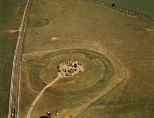
Background imageGeography Collection: United Kingdom, England, Wiltshire, Aerial view of megalithic monument of Stonehenge

United Kingdom, England, Wiltshire, Aerial view of megalithic monument of Stonehenge
Aerial view of megalithic monument of Stonehenge (UNESCO World Heritage List, 1986) - Wiltshire, England, United Kingdom

Background imageGeography Collection: Map of the United Kingdom

Map of the United Kingdom

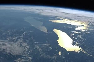
Background imageGeography Collection: The Great Lakes, ISS image C016 / 3870

The Great Lakes, ISS image C016 / 3870
The Great Lakes. View from the International Space Station (ISS) of the Great Lakes of the USA and Canada. North is towards upper right. Here, the ISS is over a point to the southeast of Nova Scotia

Background imageGeography Collection: Beach at St. Helens Conservation Area, St. Helens, Tasmania, Australia, Pacific

Beach at St. Helens Conservation Area, St. Helens, Tasmania, Australia, Pacific

Background imageGeography Collection: antiquity, archival, cartography, city, england, europe, geographical, geography

antiquity, archival, cartography, city, england, europe, geographical, geography, great britain, historical, london, map, nobody, old-fashioned, roads, streets, text, thames river, uk, urban

Background imageGeography Collection: 1818, Pinkerton Map of Chile, John Pinkerton, 1758 - 1826, Scottish antiquarian, cartographer

1818, Pinkerton Map of Chile, John Pinkerton, 1758 - 1826, Scottish antiquarian, cartographer, UK

Background imageGeography Collection: 1784, Bocage Map of the City of Athens in Ancient Greece, topography, cartography

1784, Bocage Map of the City of Athens in Ancient Greece, topography, cartography
1784, Bocage Map of the City of Athens in Ancient Greece

Background imageGeography Collection: 1865, Spruner Map of the British Isles, England, Scotland, Ireland, topography, cartography

1865, Spruner Map of the British Isles, England, Scotland, Ireland, topography, cartography
1865, Spruner Map of the British Isles, England, Scotland, Ireland

Background imageGeography Collection: 1839, Bradford Map of New York City, New York, topography, cartography, geography

1839, Bradford Map of New York City, New York, topography, cartography, geography
1839, Bradford Map of New York City, New York

Background imageGeography Collection: 1770, Bonne Map of China, Korea, Japan and Formosa, Rigobert Bonne 1727 - 1794, one

1770, Bonne Map of China, Korea, Japan and Formosa, Rigobert Bonne 1727 - 1794, one of the most important cartographers of the late 18th century

Background imageGeography Collection: 1683, Mortier Map of North America, the West Indies, and the Atlantic Ocean, topography

1683, Mortier Map of North America, the West Indies, and the Atlantic Ocean, topography
1683, Mortier Map of North America, the West Indies, and the Atlantic Ocean

Background imageGeography Collection: Antique map of the Key Islands

Antique map of the Key Islands

Background imageGeography Collection: Page from the Illustrated London News with map

Page from the Illustrated London News with map

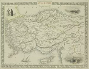
Background imageGeography Collection: Antique map of Asia Minor

Antique map of Asia Minor

Background imageGeography Collection: Aurora borealis over the Yukon River, Whitehorse, Yukon, Canada

Aurora borealis over the Yukon River, Whitehorse, Yukon, Canada

Background imageGeography Collection: Germany - Middle Rhine Valley (UNESCO World Heritage List, 2002) - Koblenz

Germany - Middle Rhine Valley (UNESCO World Heritage List, 2002) - Koblenz
Germany - Rheinland-Palatinate - Middle Rhine Valley (UNESCO World Heritage List, 2002) - Koblenz. Rivers Rhine and Mosel meet at german corner (Deutsches Eck)

Background imageGeography Collection: Elephants. Serengeti. Tanzania. Africa

Elephants. Serengeti. Tanzania. Africa

Background imageGeography Collection: Glacial rock, Halifax 1873

Glacial rock, Halifax 1873
A photograph taken during the voyage of H.M.S. Challenger (1872-1876), funded by the British Government for scientific purposes

Background imageGeography Collection: Soviet Arctic explorer Papanin, 1937

Soviet Arctic explorer Papanin, 1937
Soviet Arctic explorer Ivan Papanin (1894-1986) in 1937 while commanding the first Soviet drifting station " North Pole-1". Expedition members and equipment are in the background

Background imageGeography Collection: Otto Schmidt, Soviet Arctic explorer

Otto Schmidt, Soviet Arctic explorer
Otto Yulievich Schmidt (left, 1891-1956), Soviet Arctic explorer and geophysicist, greeting one of the rescue pilots (right) during the Chelyuskin expedition to the Arctic

Background imageGeography Collection: Navigation

Navigation. Dividers and compass sitting on a map

Background imageGeography Collection: Mannheim, satellite image

Mannheim, satellite image
Mannheim, Germany, satellite image. Mannheim is situated in the state of Baden-Wuttemburg. The city has a population of around 320

Background imageGeography Collection: Hemel Hempstead, UK, aerial image

Hemel Hempstead, UK, aerial image
Hemel Hempstead, UK, aerial photograph. Hemel Hempstead is a town in Hertfordshire, England. It was developed after World War II as a new town, but has existed since the 8th century

Background imageGeography Collection: Aerial view of Amazonian rainforest, Ecuador

Aerial view of Amazonian rainforest, Ecuador
An aerial view of the rainforest canopy in Amazonian Ecuador

Background imageGeography Collection: The forests of Grenada

The forests of Grenada

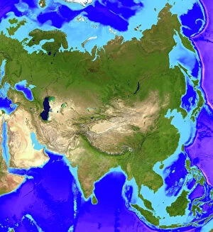
Background imageGeography Collection: Asia

Asia. Computer artwork, based on a satellite image, of Asia. North is at top. Water is blue, vegetation is green and desert is yellow

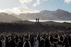
Background imageGeography Collection: Penguin breeding colony research

Penguin breeding colony research, with researchers and photographers in the background. Located at St Andrews Bay, this is the largest breeding colony of king penguins (Aptenodytes patagonicus)

Background imageGeography Collection: Spider rock, Arizona, USA

Spider rock, Arizona, USA
Spider Rock (lower centre left). This eroded sandstone spire is located in Canyon de Chelley National Monument, Arizona, USA

Background imageGeography Collection: Lava meeting the ocean

Lava meeting the ocean. Lava from the Kilauea volcano exploding and producing a plume of steam, smoke and gases where it meets the Pacific Ocean


All Professionally Made to Order for Quick Shipping

"Exploring the Rich Tapestry of Geography: From Ancient Maps to Modern Wonders" The Al-Idrisi's world map from 1154 takes us back in time, showcasing the early understanding and its importance in navigation. Derwent Water, with Blencathra standing tall behind it, offers a breathtaking view of nature's wonders in the Lake District, Cumbria, England. Jacopo de Barbari's Map of Venice in 1500 allows us to delve into the intricate layout of this enchanting city built on water. An antique map of Tasmania reveals how explorers once charted unknown territories and expanded our knowledge about distant lands. The V & A waterfront and Table Mountain create an awe-inspiring backdrop for Cape Town, South Africa – a testament to geography shaping stunning landscapes. Continental drift after 250 million years shows us that our planet is constantly evolving, reminding us of the dynamic forces at work beneath Earth's surface. Malham Cove stands as a geological marvel within Yorkshire Dales National Park, captivating visitors with its limestone formations carved by natural processes over millennia. Whole Earth (Blue Marble 2000) provides a mesmerizing image capturing our beautiful planet from space – highlighting both its vastness and interconnectedness through geography. The British Empire world map from the 19th century reflects an era when geographical exploration played a significant role in expanding colonial influence across continents. James Craig's Map of New Town Edinburgh from 1768 showcases meticulous topography planning that shaped one of Scotland's most iconic cities even today. Anglo-Saxon 10th-century world map gives insight into early European perceptions and interpretations regarding global geography during medieval times In summary, these diverse hints remind us that geography is not just about maps but also encompasses breathtaking landscapes, historical perspectives on human exploration and settlement, and the ever-changing nature of our planet.