Home > Europe > United Kingdom > England > London > Museums > National Maritime Museum
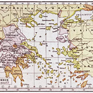
Archipeligo, Rhodes Island, town and ports of Rhodes surveyed by Commander Thomas Graves, HMS Beacon 1838, 1844 (print)
")
![]()
Wall Art and Photo Gifts from Fine Art Finder
Archipeligo, Rhodes Island, town and ports of Rhodes surveyed by Commander Thomas Graves, HMS Beacon 1838, 1844 (print)
7342500 Archipeligo, Rhodes Island, town and ports of Rhodes surveyed by Commander Thomas Graves, HMS Beacon 1838, 1844 (print) by Walker, J. & C. (19th century); 67.5x50 cm; National Maritime Museum, London, UK; (add.info.: Creator: British Admiralty; J. & C. Walker; Commander Thomas Graves; R.B. Bate
Scale: [circa 1:5, 500]. One view. Ungraduated. No watermark date.); © National Maritime Museum, Greenwich, London
Media ID 38516486
© © National Maritime Museum, Greenwich, London / Bridgeman Images
Islands Isles Rhodes Greece Greek
FEATURES IN THESE COLLECTIONS
> Animals
> Insects
> Hemiptera
> Black Scale
> Europe
> Greece
> Related Images
> Europe
> United Kingdom
> England
> London
> Boroughs
> Greenwich
> Europe
> United Kingdom
> England
> London
> Museums
> British Museum
> Europe
> United Kingdom
> England
> London
> Museums
> Greenwich Heritage Centre
> Europe
> United Kingdom
> England
> London
> Museums
> National Maritime Museum
> Europe
> United Kingdom
> England
> London
> Sights
> British Museum
> Europe
> United Kingdom
> England
> London
> Towns
> Greenwich
> Fine Art Finder
> Artists
> J. & C. Walker
> Fine Art Finder
> Artists
> John Everett Millais
EDITORS COMMENTS
This stunning print captures the beauty and intricacy of Archipeligo, Rhodes Island, as surveyed by Commander Thomas Graves aboard the HMS 'Beacon' in 1838 and 1844. The detailed map, created by British Admiralty and J. & C. Walker, showcases the town and ports of Rhodes with precision and accuracy.
The black-and-white image transports us back to the 19th century, a time when cartography was both an art form and a scientific endeavor. The scale of approximately 1:5,500 allows for a comprehensive view of the island's layout, highlighting its unique geography and topography.
As we gaze upon this historical artifact from the National Maritime Museum in London, we are reminded of the importance of exploration and discovery in shaping our understanding of the world. The intricate details captured in this print serve as a testament to the dedication and skill of those who charted unknown territories for future generations to study and admire.
From city streets to winding coastlines, every inch of Archipeligo is meticulously documented on this map. It serves as a window into a bygone era when sailors braved uncharted waters in search of new horizons. Commander Thomas Graves' legacy lives on through this remarkable piece of cartographic history that continues to inspire awe and wonder today.
MADE IN THE USA
Safe Shipping with 30 Day Money Back Guarantee
FREE PERSONALISATION*
We are proud to offer a range of customisation features including Personalised Captions, Color Filters and Picture Zoom Tools
SECURE PAYMENTS
We happily accept a wide range of payment options so you can pay for the things you need in the way that is most convenient for you
* Options may vary by product and licensing agreement. Zoomed Pictures can be adjusted in the Cart.