Home > Animals > Mammals > Muridae > Western Mediterranean Mouse
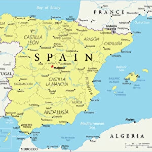
Map of the Western Mediterranean countries: France, Spain

![]()
Wall Art and Photo Gifts from Fine Art Finder
Map of the Western Mediterranean countries: France, Spain
LRI4711223 Map of the Western Mediterranean countries: France, Spain, Portugal and North Africa (Morocco, Algeria, Tunisia), with the Baleares, Corsica and Sardinia (etching, 1717) by Nolin, Jean-Baptiste (c.1657-1708); Private Collection; (add.info.: Map of the Western Mediterranean countries: France, Spain, Portugal and North Africa (Morocco, Algeria, Tunisia), with the Baleares, Corsica and Sardinia - Engraving from the atlas le theatre du monde, 1717, by Jean Baptiste Nolin (1686-1762) - Map of the Western Mediterranean - From " Le Theatre du Monde" 1717 by Jean-Baptiste Nolin); Luisa Ricciarini; French, out of copyright
Media ID 22837422
© Luisa Ricciarini / Bridgeman Images
Atlas Book Corsican Maghrebin Maghrebine Portugal Portuguese Sardinia Geographical Map Maghreb
FEATURES IN THESE COLLECTIONS
> Africa
> Algeria
> Related Images
> Africa
> Morocco
> Related Images
> Africa
> Related Images
> Africa
> Tunisia
> Related Images
> Animals
> Mammals
> Muridae
> Western Mediterranean Mouse
> Animals
> Mammals
> Muridae
> Western Mouse
> Fine Art Finder
> Artists
> Jean-Baptiste Nolin
EDITORS COMMENTS
This print showcases a beautifully detailed map of the Western Mediterranean countries from the 18th century. Created by Jean-Baptiste Nolin, a renowned cartographer of his time, this engraving is part of the atlas "Le Theatre du Monde" published in 1717. The map encompasses France, Spain, Portugal, and North Africa (Morocco, Algeria, Tunisia), along with the islands of Baleares, Corsica, and Sardinia. The intricate etching highlights not only geographical features but also cultural connections between these regions. It provides an invaluable historical perspective on trade routes and political boundaries during that era. This particular print is housed in a private collection and has been preserved meticulously over time. Luisa Ricciarini's expert photography captures every minute detail of this remarkable piece of art. The colors are vibrant yet true to the original work while maintaining its vintage charm. Through her lens, we can appreciate the craftsmanship involved in creating such an elaborate map. Whether you are a history enthusiast or simply fascinated by cartography and geography, this print offers a glimpse into the past and invites exploration into the interconnectedness of nations across borders. It serves as both an educational tool and a stunning visual representation of our ever-evolving world.
MADE IN THE USA
Safe Shipping with 30 Day Money Back Guarantee
FREE PERSONALISATION*
We are proud to offer a range of customisation features including Personalised Captions, Color Filters and Picture Zoom Tools
SECURE PAYMENTS
We happily accept a wide range of payment options so you can pay for the things you need in the way that is most convenient for you
* Options may vary by product and licensing agreement. Zoomed Pictures can be adjusted in the Cart.