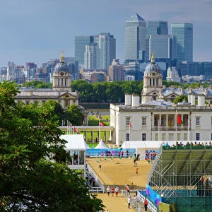
Home > Europe > United Kingdom > England > London > Museums > National Maritime Museum
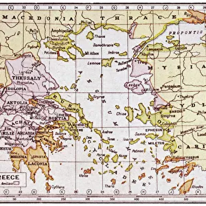
Chart of Negroponte, c.1485 (Vellum)
")
![]()
Wall Art and Photo Gifts from Fine Art Finder
Chart of Negroponte, c.1485 (Vellum)
7340068 Chart of Negroponte, c.1485 (Vellum) by Sonetti, Bartolomeo da li (fl.1485); 27.5x19 cm; National Maritime Museum, London, UK; (add.info.: Creator: Bartolommeo dalli Sonetti
Scale: 1:5 000 000. The chart also shows Evvia and is from an Isolario (island book). The text is in verse, dedicated to Giovanni Mozenico, Doge of Venice 1475-1485.); © National Maritime Museum, Greenwich, London
Media ID 38515522
© © National Maritime Museum, Greenwich, London / Bridgeman Images
Islands Isles 15th 15 Xv Xvth Fifteenth Century Geographer Greece Greek
FEATURES IN THESE COLLECTIONS
> Europe
> Greece
> Related Images
> Europe
> United Kingdom
> England
> London
> Boroughs
> Greenwich
> Europe
> United Kingdom
> England
> London
> Museums
> Greenwich Heritage Centre
> Europe
> United Kingdom
> England
> London
> Museums
> National Maritime Museum
> Europe
> United Kingdom
> England
> London
> Towns
> Greenwich
> Europe
> United Kingdom
> Heritage Sites
> Maritime Greenwich
> Europe
> United Kingdom
> Maps
> Fine Art Finder
> Artists
> Bartolomeo da li Sonetti
> Fine Art Finder
> Artists
> Hendrick Doncker
> Historic
> Ancient civilizations
> Ancient Greece
> Greek history
EDITORS COMMENTS
This stunning print of the Chart of Negroponte, dating back to around 1485, offers a fascinating glimpse into the intricate world of cartography in the 15th century. Created by Bartolomeo da li Sonetti, this vellum chart showcases a detailed map of Negroponte (now known as Euboea) and Evvia, along with other surrounding islands.
The scale of 1:5,000,000 provides a comprehensive view of the region, while the text written in verse adds an artistic touch to this historical piece. Dedicated to Giovanni Mozenico, Doge of Venice from 1475-1485, this chart serves as both a navigational tool and a work of art.
The vibrant colors used in this drawing bring life to the geography depicted on the map. The meticulous attention to detail highlights the skill and precision required for creating such maps during that time period.
As you admire this print from the National Maritime Museum in London, you can't help but marvel at how far we've come in terms of cartography and technology. This piece is not just a map; it's a window into history and an example of fine art that continues to captivate viewers centuries later.
MADE IN THE USA
Safe Shipping with 30 Day Money Back Guarantee
FREE PERSONALISATION*
We are proud to offer a range of customisation features including Personalised Captions, Color Filters and Picture Zoom Tools
SECURE PAYMENTS
We happily accept a wide range of payment options so you can pay for the things you need in the way that is most convenient for you
* Options may vary by product and licensing agreement. Zoomed Pictures can be adjusted in the Cart.