Home > Arts > Artists > L > Louis IX Louis IX
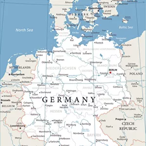
Map of Germania following Treaty of Verdun in 843 dividing the Charlemagne Empire into three parts among the sons of Louis the Pious: the Western Francie, the Median Francie and the Eastern Francie, Engraving from " Atlas Universel" by Houze, 1851

![]()
Wall Art and Photo Gifts from Fine Art Finder
Map of Germania following Treaty of Verdun in 843 dividing the Charlemagne Empire into three parts among the sons of Louis the Pious: the Western Francie, the Median Francie and the Eastern Francie, Engraving from " Atlas Universel" by Houze, 1851
ELD4924537 Map of Germania following Treaty of Verdun in 843 dividing the Charlemagne Empire into three parts among the sons of Louis the Pious: the Western Francie, the Median Francie and the Eastern Francie, Engraving from " Atlas Universel" by Houze, 1851; (add.info.: Geographic map of Germania following the demise of the Charlemagne Empire in 843 (Treat of Verdun) dividing the Charlemagne Empire into three parts: the Western Francie (Ancetre de France), the Median Francie and the Eastern Francie (Ancetre de la Germany) (Map of carolingian empire at the times of Treaty of Verdun that divided the empire into three kingdoms among the three surviving sons of Louis the Pious) Engraving from " Atlas Universel" by Houze, 1851 Private collection); Photo © The Holbarn Archive
Media ID 38169634
© © The Holbarn Archive / Bridgeman Images
800 899 9 9th 9th 9th Century 9 9th Ix Ixth Century 9 Century 9th Century C9th Carolingian Carolingian Dynasty Carte Geographique Charlemagne Charlemagne Empereur Geographie Ix Century Ixth Century Moyen Age Geographical Map Isadora
FEATURES IN THESE COLLECTIONS
> Arts
> Artists
> L
> Louis IX Louis IX
> Fine Art Finder
> Artists
> Greek
> Maps and Charts
> Related Images
EDITORS COMMENTS
This print showcases a historical map of Germania following the Treaty of Verdun in 843, which marked the division of the mighty Charlemagne Empire into three distinct parts among the sons of Louis the Pious. The Western Francie, Median Francie, and Eastern Francie are clearly delineated on this engraving from "Atlas Universel" by Houze, dating back to 1851.
The intricate details on this map offer a glimpse into a pivotal moment in European history when power struggles and territorial disputes shaped the future of nations. The legacy of Charlemagne's empire lives on through these divisions, with each region eventually evolving into what we now know as France and Germany.
As you study this map closely, you can almost feel the weight of history resting upon it. The lines drawn here represent more than just borders—they symbolize centuries of political intrigue, cultural exchange, and warfare that have left an indelible mark on Europe.
Whether you're a history buff or simply intrigued by ancient cartography, this print is sure to spark your imagination and transport you back to a time when empires rose and fell at the stroke of a pen. It serves as a reminder that even great powers must eventually yield to change—and that every kingdom has its own story to tell.
MADE IN THE USA
Safe Shipping with 30 Day Money Back Guarantee
FREE PERSONALISATION*
We are proud to offer a range of customisation features including Personalised Captions, Color Filters and Picture Zoom Tools
SECURE PAYMENTS
We happily accept a wide range of payment options so you can pay for the things you need in the way that is most convenient for you
* Options may vary by product and licensing agreement. Zoomed Pictures can be adjusted in the Cart.